Climate-Weather Sessions: General Instructions
Fall 2015
Students leading discussions of current climate and weather should
start with the broad scale and then gradually zoom in on the local.
The region you zoom into is your choice. It might be, for example,
your home state or province.
Specifically, follow these steps:
- Step 1: Review the monthly or seasonal climatological patterns
for surface
pressure and 500 hPa height to establish the average circulation for
your region. As available, review the temperature, humidity and
precipitation climatology.
- Step 2: Review the recent (approx. past 2 days) weather across
your region (i.e., the large-scale weather). Primary attention
should be given
to evolution of circulation fields like 500 hPa heights and sea-level pressure,
followed by other fields they affect, like precipitation, temperature,
windiness, cloud cover, etc.
- Key Question: How do these fields adhere to or
depart from climatology? This should set the stage for Step 3.
- Step 3: Focus on the current weather in your region.
- Note
again whether this is typical or anomalous weather compared to climatology.
- Step 4: Using forecasts of the circulation fields, discuss how the
forecasted change will affect affect temperature, rainfall, cloud
cover, winds, etc. over the next 2 days or so.
- Step 5: Give some example(s) of how the recent, current or forecasted
weather affects your community at large. For example, unseasonably
cold weather might delay planting of crops, unusual wet weather might
be producing flooding in some communities, windy weather might affect
ocean conditions (perhaps for diving or surfing!).
- In other words, why are this season's climate and weather so
important? What are the broader impacts of this season's
climate and weather?
Some further notes:
- Your presentation should follow the usual steps for a conference
presentation or seminar:
- Introduce yourself and give a quick overview of what you will be
talking about. That is, state what will be the key points, to
orient the audience.
- Then present your material illustrating your points.
- Finish with a summary, that highlights the key points you showed.
- In the context of this course, when you present the recent and
forecasted weather, place it in the context of the climatology you
just showed. What is the similarity and contrast between the
current weather and what one might expect from climatology? How
much does the climatology shape the current weather?
- The whiteboard capabilities of the Adobe Acrobat Connect environment can
be very useful for highlighting specific features, if conducted over
the Internet.
- Various web-based resouces are available, among them:
- Climatology:
-
Annual Cycle maps from the U.S. Climate Prediction Center (CPC).
Note that the averaging periods are not the same for all fields. The
maps include global as well as US-specific coverage. The
Pentad Mean (5-day average) animations are especially nifty.
- US:
- Africa:
Other useful sites for Southern Hemisphere weather:
- Australia: Bureau
of Meteorology, Commonwealth of Australia.
- Argentina: Centro de
Investigaciones del Mar y la Atmósfera, Universidad de
Buenos Aires.
- Remember that you will be presenting to students who are in
another country or who might not be originally from the region of their
university (e.g., some graduste students). Thus, repeating
information about climatology that was given in a previous session is
not only acceptable, it is highly recommended.
- Questions from participants are expected! This is an
opportunity to learn about the climate and weather of somewhere else
from a native - any question somehow weather-related is relevant (note
Step 5).
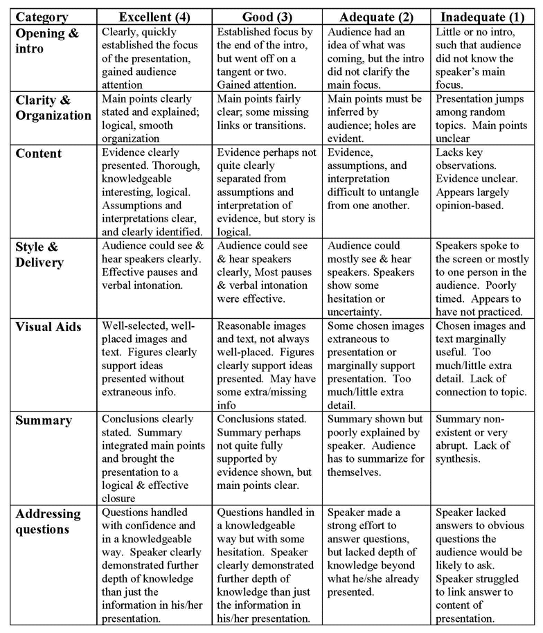
Rubric for Evaluating Climate-Weather Presentations
Go to main
web page for Climate Modeling.