1-10: Ocean Structure and Circulation | 1-10: En Español | 1-10: Em Português |
Conduction, Convection,
and Radiation
Oceans are critically important in the movement of heat over the
planet. In elementary school you learned that heat moves by conduction,
convection, and radiation. Radiation and conduction are effective in
moving heat vertically from the earth's surface, but are relatively
unimportant in moving heat horizontally. Water, like air, is a fluid that
can carry heat as it moves from one place to another. Meteorologists have
different terms for horizontal and vertical movement of fluids: movement
in the vertical direction driven by buoyancy is called convection, and
movement in the
horizontal direction is called advection. Convection contributes, with
radiation and conduction, to the movement of heat in the vertical
direction. But advection is essentially the sole process by which heat
moves laterally over the surface of the earth.
Water Transport of Heat
Water is about 1,000 times as dense as air, and, since the amount
of thermal energy transported by a moving fluid is proportional to its
density, a volume of water can transport about a thousand times as much
heat as an equivalent volume of air. The rate at which heat is
transported, called the heat flux, is measured in Joules of energy per unit
area per unit time, so the rate at which heat is transported is also
proportional to the speed of movement (wind speed in air or current speed
in the ocean). Since wind speed is typically on the order of 10 meters
per
second and ocean drift currents on the order of centimeters per second, the
air speed is about a thousand times larger than ocean speed. Therefore,
air moves a thousand times faster than water but carries only about 1/1000
as much heat per unit volume, which suggests that water is approximately of
equal importance to air in moving heat over the planet.
Ocean Circulation
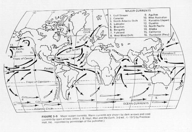
Figure 1
shows the major movement of water in the oceans of
the world. Note the location of the Equator and the general direction of
motion in the Northern and Southern Hemisphere. The Southern Hemisphere
has major counterclockwise circulation gyres in the South Pacific and South
Atlantic Oceans. The Indian Ocean directly west of Australia also has a
smaller gyre, with an even smaller circulation pattern in the Arabian Sea
and Bay of Bengal to the north. These circulation patterns all contribute
to create a west-to-east flow around the rather circular Antarctic continent
and a generally east-to-west flow around the equator.
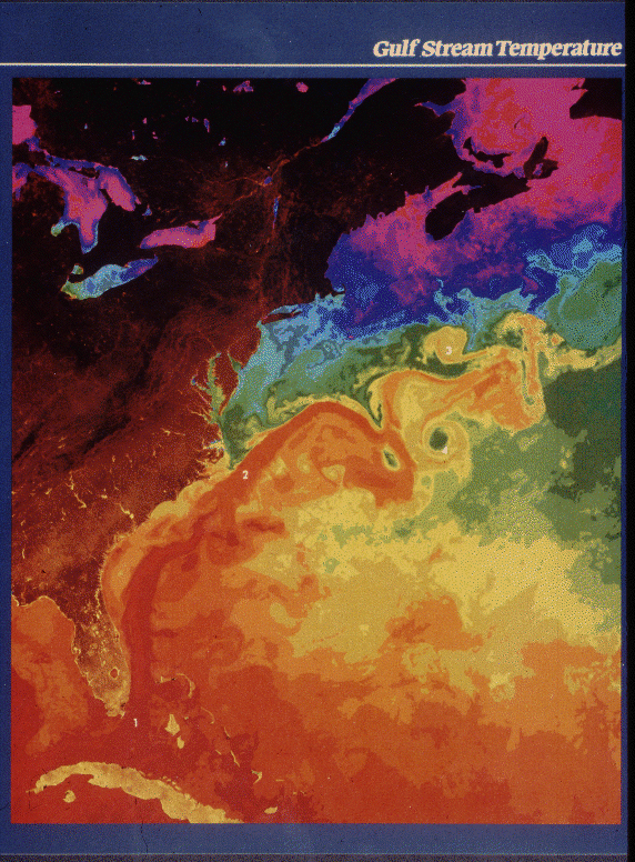
The clockwise circulation patterns in the Northern Hemisphere include a single gyre in the North Atlantic and two cells in the North Pacific Ocean. At latitudes above N, circulation patterns become more complicated due to interactions with continents and the Arctic Ocean, but where smaller circulations exist, clockwise rotation is preserved. Note the position and direction of the Gulf Stream off the east coast of the US and the North Atlantic drift current between Greenland and Scandinavia. A close-up satellite picture of the Gulf Stream, with color enhancement to show temperatures, shows the horizontal extent of the warm current and the eddy structure that develops off the New England coast (Figure 2).
An interesting consequence of these circulations is that, in both hemispheres, the west coasts of continents generally have flow toward the Equator and east coasts have flow away from the Equator. Other factors being equal, this suggests that west coasts of continents will have slightly cooler water offshore compared to east coasts at the same latitude. In the US, the water off northern California is much colder than off New York, at the same latitude.
Gulf Stream
The Gulf Steam carries warm tropical water off the east coast of
the US in a direct path toward Great Britain and the Scandinavian
countries, giving these regions a far warmer climate than, say, Alaska
which is at a comparable latitude. The Gulf Stream moves at a speed that in some
places exceeds 1.5 m/s.
Coriolis Force
The rotation in the major ocean basins is driven by a combination
of wind stress at the ocean surface and the Coriolis force due to the
earth's rotation. As discussed in the unit on atmospheric structure and
circulation (Unit
1.3),
the winds at the earth's surface are directed from east to west in at
the Equator and generally west to east at the middle latitudes (30 to
60
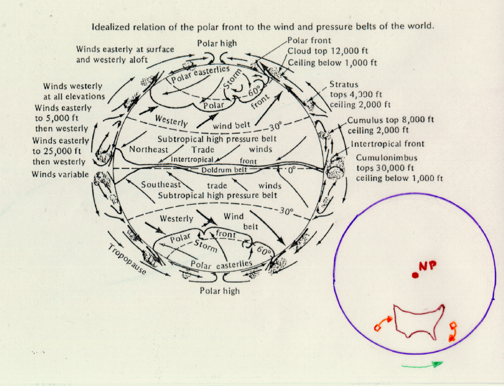
The effect of the Coriolis force can be visualized by considering the ocean circulation as seen from the North Pole as in Figure 4. The earth rotates as shown by the green arrow. The law of conservation of momentum says that in the absence of forces, the momentum of an object does not change. A parcel of water (or air) that has a component of its velocity toward the Equator (outer boundary of the circle) will be moving to positions at greater distance from the polar axis. Because of the rotation of the earth, the total speed of the parcel will increase (and violate the law of conservation of momentum) unless it moves in the direction opposite to the rotation, as shown, and follows a path that curves to the right. A parcel moving towards the axis of rotation (northward in the Northern Hemisphere) similarly will move in a clockwise direction. For flow south of the Equator, the same reasoning leads to the conclusion that rotation in the Southern Hemisphere is in the counterclockwise direction.
Global Circulation Pattern
Figure 5
gives a conceptual picture of the global circulation
pattern that links the major ocean basins of the planet. The large region
of open ocean in the Equatorial Pacific allows significant warming of water
as it drifts to the west and past the northern edge of Australia. This
warm surface water drifts on westward through the Indian Ocean and around
the Southern tip of Africa. From here it turns northward, crossing the Equator
(taking a more easterly direction than shown here), and creating the Gulf
Stream off eastern North America. The warm surface water continually cools
as it moves northward past Great Britain and into the Norwegian Sea. By
this time the water is sufficiently cold and dense that it sinks to lower
depths in the ocean. This creates the start of the global scale return
current at low depths that moves southward across the Equator, back around Africa, past the southern edge of Australia and back to the
central Pacific Ocean. A smaller branch of the return current splits off
after passing Africa and enters the Indian ocean where sufficient warming
augments the warm surface current coming from the central Pacific.
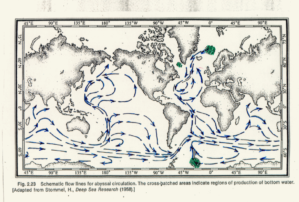
Flow in the lower depths of the ocean is shown in Figure 6. Of particular note in this graph are the regions of subsidence (downward motion) northeast of Iceland and in the south Atlantic near Antarctica, which remove water from the surface and deliver it to deeper levels in the ocean. A third subsidence region of lesser extent exists in the Labrador Sea between Laboratory and Greenland. To understand the reason for these subsidence regions we must examine the driving forces for vertical circulation in the ocean.
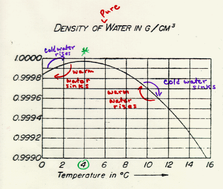
Density of Water
Vertical motions in the ocean are driven by small differences in
water density due to differences in salinity (salt content) and (or)
differences in temperature. Increased salt content increases density of
water, and generally cold water is more dense than warm water, with one
profound exception. Figure 7 describes the
density of pure water as a function of temperature. It is apparent that density goes up as
temperature decreases from
Effect of Salinity
The ocean does not have a uniform salinity. As ocean water flows
toward the polar region from the Equator, it passes the subtropical
high-pressure zones that have very little precipitation but intense solar
radiation that promotes evaporation. In regions where evaporation is high,
the salt content of the remaining surface water increases, thereby
increasing the density. The Mediterranean Sea receives relatively low
amounts of input from rivers but a large amount of evaporation due to
persistent clear skies and intense solar radiation. As a result, very
dense water is created in the basin which spills out at the basin bottom at
the Strait of Gibraltar, drawing less salty water into the basin at the
upper surface. This effect is graphically revealed in Figure 8.
In regions where precipitation is high, such as the Intertropical Convergence Zone in the central Pacific Ocean shown in the unit on Atmospheric Structure and Circulation (Figure 9), fresh-water rain will ride on top of the saline ocean water. Similarly melting ice in polar regions will be less dense than nearby ocean water of temperature because of its lower temperature and lack of salt.
These concepts of density dependence on temperature and salinity explain the linkage of surface water to the abyssal (deep ocean) circulation. In the North Atlantic ocean, water traveling northward at the surface passes through the subtropical high pressure zone and experiences a density increase due to evaporation. As it continues norward evaporation continues to increase the salinity and hence the density, but cooling due to heat loss to the atmosphere also contributes to increasing the density. Ultimately the density increases to the extent that massive subsidence is created to the north of Iceland. The subsidence region in the Southern Hemisphere is explained for the same reason, since warm water from the tropical Pacific has experienced both evaporation and cooling by the time it reaches the region north of the Weddell Sea (southeast of the southern tip of South America).
The vertical circulation caused by density differences due to differences in ocean temperature and salinity is called the thermohaline circulation. Horizontal global ocean circulation is driven by wind stress at the ocean surface, but vertical mixing is largely due to the thermohaline circulation. A nice aminated depiction is given by the Climate Research Unit of the University of East Anglia.
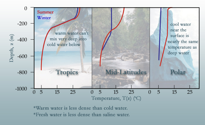
Vertical
Mixing
Figure 10
shows the effect of vertical temperature
profile on mixing at different latitudes. In the tropics, shown in the
left graph, surface water is very warm and rides on top of much colder
water at depths below 200 m and prohibits vertical mixing. In polar
regions, by contrast, cool water formed at the surface has the ability to
mix to deep layers or even, with excess salt content, move to the ocean
floor and become part of the abyssal horizontal flow pattern. We will
return to this production of deep water in polar regions when we discuss
sea level rise in Block 2.
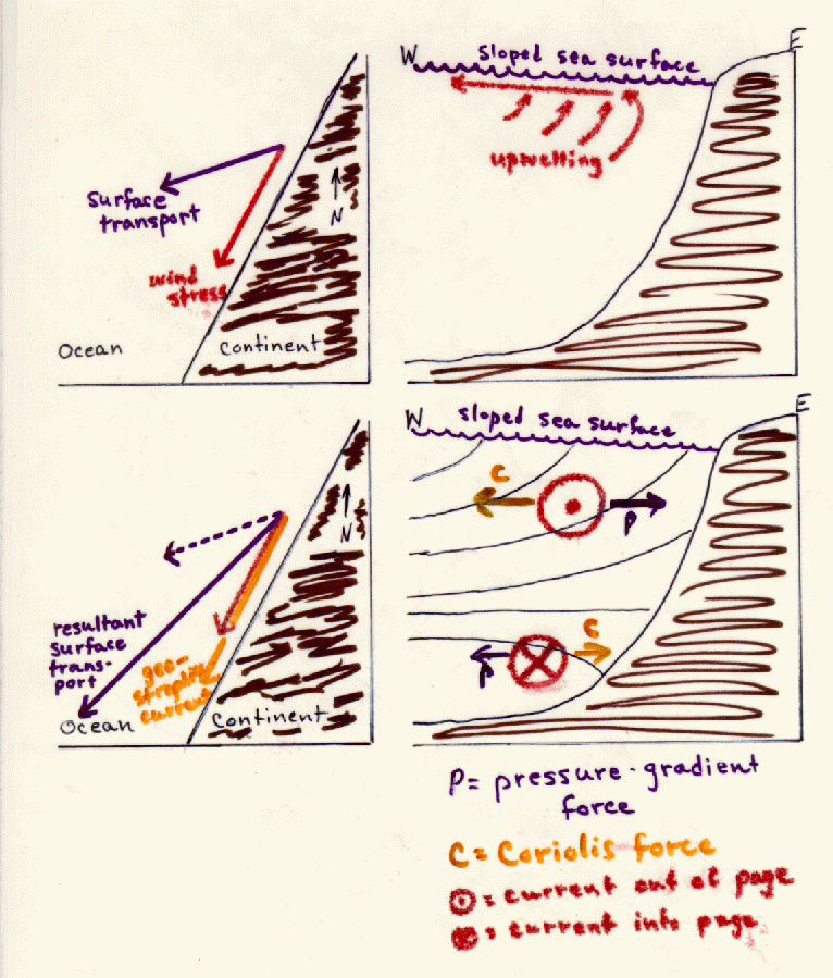
Coastal Currents and Land Mass Interactions
Figure 1 of this unit showed the existence of strong
ocean currents along coastlines of continents. The interaction of the
coastal currents with the land mass leads to important characteristics of
the temperature and biological activity in these regions. Figure 11 shows coastal flow in the Northern Hemisphere with a wind generally
from north to south parallel to the west coast of a continent. The
Coriolis force provides a force to the right of the wind and tends to
transport surface water away from the continent. This lowers sea level
slightly near the continent and draws colder water from deeper levels leading to
what we call upwelling. The sloped ocean surface also establishes a force
directed toward the continent. Flow resulting from this force also is
deflected to the right (in the Northern Hemisphere) further intensifying
the southward coastal flow along the continent. A wind from the south on
the east coast of a continent in the Northern Hemisphere will have the same
effect.
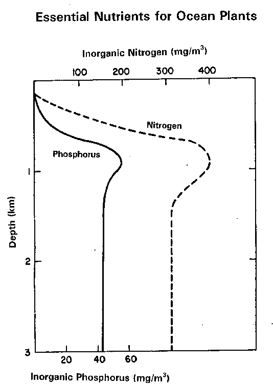
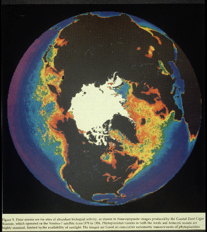
Upwelling along continental coastlines brings colder, nutrient-rich waters (Figure 12) from deeper layers into the euphotic zone and promotes rich biological activity (Figure 13) as previously shown in satellite pictures of the Northern Hemisphere (Figure 14) and Southern Hemisphere (Figure 15). A close-up of the California coast shows the abundance of phytoplankton off the coast of Northern California (Figure 16).
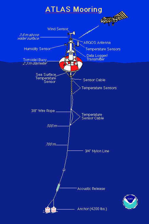
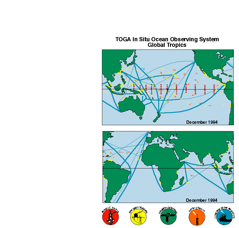
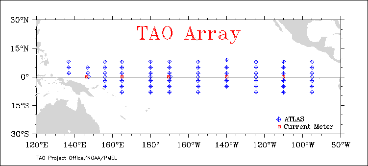
Measurements of meteorological and oceanographic data at remote locations in the ocean are made with moored buoys such as the Atlas system (Figure 17). During the Tropical Atmosphere/Global Ocean (TOGA) experiment a network of such moored buoys was deployed (Figure 18). The Pacific array presently provides real-time measurements of sea-surface temperatures (Figure 19). These will be of considerable interest when we begin discussing El Nino. A variety of surface and subsurface ocean data can be accessed online. Data from an oceanographic research ship presently in the TOA array also can be accessed in real-time.
Satellites provide complete mapping of sea surface temperatures in real-time as is shown on this map of sea surface temperatures of today.