Summary based on a study by William Koellner, US Army Corps of Engineers, Rock Island, IL.

The Mississippi River is 2,340 miles long and has a watershed area of 1,245,000 square miles. Forty percent of the area of the United States and 13 percent of the area of Canada drain into this river system. There are multiple uses of the river's waters, ranging from recreation to transportation. Many of these uses generate conflict over management strategies as well as tactics. In 1976 the US Congress authorized the development of a river system management plan in order to resolve conflict over usage, noting that usage of the system would not be permitted to degrade it. In 1986 the Upper Mississippi River Management Act declared the intent of Congress to recognize the system as a nationally significant ecosystem as well as a nationally significant commercial navigation system.
The Mississippi River navigation system is an important waterway for the movement of five basic categories of commodities: grain, agricultural chemicals, coal, cement and stone, and petroleum products. Either too little or too much water can disrupt the flow of trade or at least reduce the efficiency of the system's operations. Any changes in the normal levels of flow could adversely affect sellers, buyers, and navigators.
Too much water in the system often led to the flooding of low-lying areas, higher velocity of waterflow, and a greater amount of sediment flow. In response, flood control mechanisms such as levees, channels, and modified channel depths have been relied on. High waterflow levels also have adverse impacts on the navigation network in addition to the obvious effect of flooding and its impacts on low-lying agricultural and urban communities. For example, high flows decrease maneuverability of vessels on the river, increase the incidence of boat accidents, accelerate erosion processes, increase sediment loading, and adversely affect side channel accretion, thereby destroying fish habitats.

Low-flow situations have been less frequent and operational measures to get through them have often been carried out on an ad hoc basis. There have been several periods ofgenerally low flows, such as during 1856-72, 1886-96, 1930-37. Extreme low flows also occurred in 1863-64, 1956, 1980-81, and in 1987-88. Most of the locks and dams were constructed in response to periods of low flow, especially during the 1930s. It was, for example, in 1930 that channel depths were increased from six to nine feet.
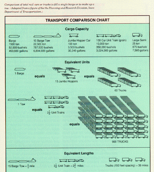
An extreme dry spell could lead to the closure of channels in the system, generating serious problems for river transportation and storage facilities. Low flows can minimize tow size and can reduce the size of the total load. Delays of shipments in this system can be extremely costly. During the 1980-81 period, levels were so low that navigation stopped altogether.

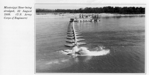
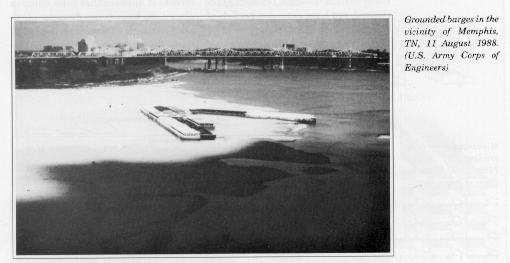
Another recent closure occurred for a ten-day period in July 1987 when several areas were at the critical 9 foot depth level necessary for the safe movement of towboats and barges with widths suitable for long-haul common carrier service. Statements from barge line officials indicated that the channel closure cost the tow companies between $250,000 and $300,000 per day. Under extremely dry meteorological conditions in the spring and summer of 1988, river levels continued to decline. These low flows caused numerous groundings of vessels and delays of traffic and movement of commodities in the in land waterways system. Several new low-water records were set both in stage and flow. Below St. Louis, considerable difficulties were encountered because of channel closures and shallow water conditions. Tow boats were bottlenecked as a direct result of extremely low-flow conditions. Dredging operations were carried out 24 hours a day during much of the summer in an attempt to maintain the movement of river traffic.

Mississippi River users as well as some government agencies continued to search for sources of additional water during the 1988 drought with such areas as the headwaters of the Mississippi River and the Great Lakes being considered. Chronic political conflicts over ownership and use of Great Lakes water surfaced once again between the United States and Canada as well as between and within US states.
Generally speaking, extended periods of low water in the Mississippi River system have not yet been experienced, nor have extended periods of high water. Interestingly, we have recently witnessed the period of greatest historical stress, 1959 to 1986; this has been the wettest 28 year period in the climate history of the Mississippi River Basin.

In summary, there is really no good analogue in the historic record for societal responses either to a prolonged wetter regime or a drier one. Most responses to hydrologic changes (usually climate induced) in the Mississippi River system have been ad hoc in the form of crisis management. Most societal actions are, in fact, responses to a given regional stress. It appears that little value is placed on long-range drought planning strategies because of the belief that the situation (hydrologic or demographic) will be so different from past situations as to render such contingency plans useless. To date, the US Army Corps of Engineers has worked from existing records and depended for planning on the identification of historical precedents. Regional climatic changes are likely to result in social, environmental, and commercial changes in the inland waterway system. If the climate is changing, to what extent will the past historical record serve as a reliable guide to the future with regard to large navigational systems? Until we know what a climate change will look like at the regional level, we may not be able to answer that question with a high degree of confidence.
