For Jayson Prentice and I, we started the day in Goodland, KS. We were awaiting the arrival of Tim and the whole crew, which ended up being a total of 6 vehicles. Prior to
their arrival, we had to make some repairs to our mobile mesonet. Tim and the gang arrived at 2pm CDT, and work began immediately on fixing Tony Laubach's mesonet.
Meanwhile, storms were already firing up and quickly becoming severe. The fix took about 20 mintues, and we took off, heading east on I-70. Shortly after, it began to rain
very heavily, accompanied by 1" hail.
We blazed east on I-70 to the town of Grainfield, and turned south on Hwy 23. We went past Gove in hopes of catching the southern most storm, and the plan was to get on Hwy
4 and head east, but we never made it. On the way, the second most southerly storm began to look more and more interesting. After we passed it by a few miles, Tim noticed a
small funnel coming out of it.
So we took the chase bait, and turned around, back toward the toward the town of Gove. It produced a very weak tornado, and that looked to be it. So our new plan was to get
on I-70 and head east to once again intercept th southern most storm. But once again, as we got to the interstate, the storm produced a funnel, which quickly evolved into a
small tornado. Tim, Tony, Verne, and National Geographic turned west on a small road north of the interstate. Bruce, Kathy, Jayson, and I continued north on 23 in hopes of
sampling some RFD. Tim's group was unable to pursue north, as the roads turned to mush. That's where we lost them. They turned around, and headed east on I-70, where they
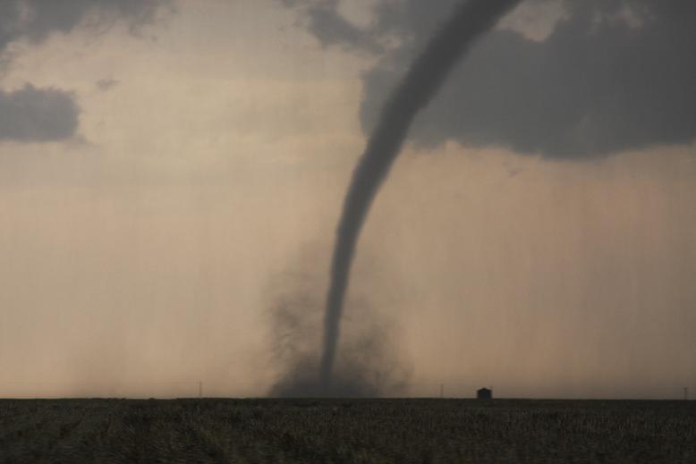
later saw a few more tornadoes. Bruce, Kathy, Jayson, and I continued north on 23, where I was able to snap this photo of the rope tornado.
I consider this is my first "official" tornado, and it was a thing of beauty. This rope tornado was snapped at 5:46pm CDT on Hwy 23 between Grainfield and Hoxie, as I was
driving. Shortly after, the tornado dissipated. However, to our north we observed a nice mesocyclone/wall cloud, so we continued north on Hwy 23 to the town of Hoxie. We
turned northwest on Hwy 24 and that's where things got wild.
This is a bad photo of a multi-vortex tornado that was developing just a few miles northwest of Hoxie, taken at 6:04 pm. Within a few minutes, this tornado evolved into a
wedge. We were able to sample the RFD on this tornado as well. Damage to power lines and homes were observed on this road.
In order for us to continue pursuing this tornado, we had turn around, go back through Hoxie, and continue north on Hwy 23... so that's what we did. North of Hoxie, we
observed two small tornadoes/gustnadoes within a hundred meters of our vehicles, one of which passed over Bruce and Kathy's car. I was very nervous. Jayson has some nice
pics of this, and we have good video. We continued north on Hwy 23 and watched the main tornado persist, with a satellite tornado as well. Within the next several minutes,
the tornadoes dissipated.
Our next concern was gasoline, as we were down to a quarter tank, and all the little towns were out of power. Luckily, we were able to make it to Hill City, though the
indicator was below the empty mark on the gas tank. On the way to Hill City, we saw a truck rolled in the ditch, with power poles bent over, and at the gas station one of
the locals said they had to cut the truck open to get the guy out.
After gassing up, our next objective was to meet back up with Tim. Shortly before making it to I-70, we decided to pull over, and not core punch the storm. This turned out
to be a good decision, as there was damage in the town on Wakeeney. We were stopped on the road just on the north side of town, and could see damage to a grain bin. We got
out and helped the emergency management clear the road.
Once we got on I-70, we traveled east to Hays, KS to meet back up with Tim and stay the night at Best Western. They also observed several tornadoes, although no probe
deployments were made, due to fast storm motions.
|