
|
|
|
|
|
|
|
|
|
|
|
|
|
|
|
|||||||
|
|
|
|
|
|
|
|
|
||
Precipitation
Analysis of precipitation records is even more difficult than temperature. Errors in precipitation
records include wind speed during rain/snow events that causes droplets/snowflakes to be deflected from
falling in the gauge by flow patterns around the instrument. This error always leads to reports of
rain being less than actually occurred, so it (like urban heat islands were for temperature) does not
experience a compensation effect when a large number of stations are aggregated. Elaborate means can be
taken to compensate for this, but such accurate instruments require more expense and maintenance.
Wetting of the gauge in light precipitation events also can lead to under-reporting of
precipitation amounts. Even if the gauges were accurate, the spatial variability of rainfall
is much larger than that for temperature, so intense rain events can be missed completely by a
sparse network. Also, intense but isolated rain even at one station in a sparse network can be
erroneously inferred to be representative of rainfall over a large area. Because this
representativeness problem may cause either positive or negative errors, a large measure of
compensation usually occurs.
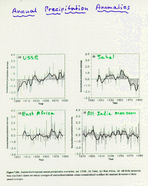
Analysis of precipitation records, Figure 3, over the globe show some regions seemingly experiencing a trend toward increasing precipitation and others decreasing. Subtle changes in large-scale flow patterns can influence precipitation patterns, so it is difficult to draw general conclusions. A global distribution of change from 1900-1994 generally shows increases at high latitudes and decreases in subtropical areas. (Figure 4)
NEXT: Temperature Above the Surface