2013 Chase Season

Season statistics:
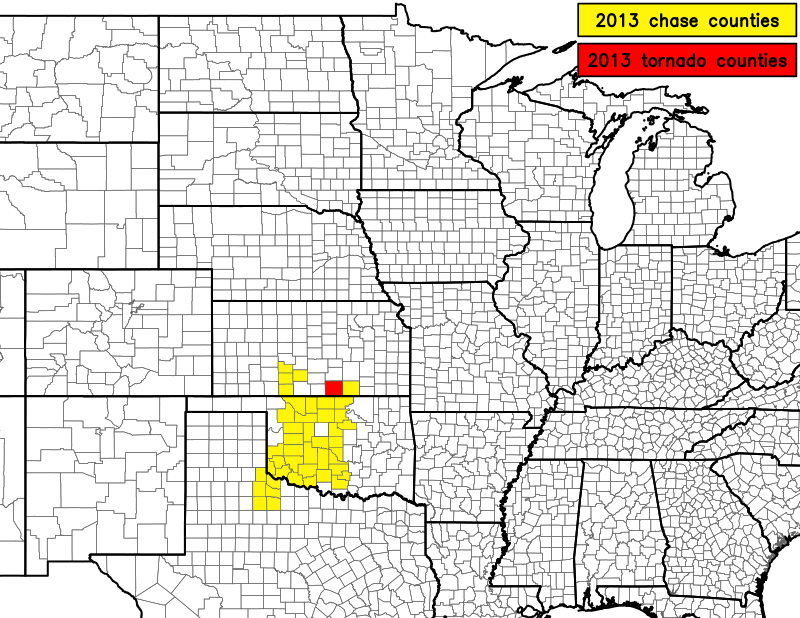
- Chases: 9
- Tornadoes: 1
- Tornado days: 1
- Miles chased: ~3400
- Cap busts: 1
- States chased in: OK, TX, KS
- Best day: none that qualify
2013 was my worst chasing year since 2008, when I also had only one tornado day (and missed Parkersburg). However, the one good
day in 2008 was much better than my one tornado day this year. This year sucked because I made the wrong decision most days.
The decision whether to go north or south or even whether or not to leave home were examples of decision points. If I calculate
chasing skill as the number of tornadoes seen while chasing
relative to the number that would have been seen by not chasing, my skill in 2013 would be negative since I probably would've seen
at least 3 tornadoes from May 19th and 20th (they were close enough for me to consider them visible without going on a full-blown chase).
Said another way, I would've had a better year chasing had I never left home until a tornado was pretty
much on the ground. 2013 also included the uncomfortably close calls from the Moore and El Reno EF5 tornadoes, as well as
the tragic loss of admired chase mentors and friends Tim Samaras, Paul Samaras, and
Carl Young in what may end up being one of the baddest tornadoes to ever have been documented (near El Reno on May 31).
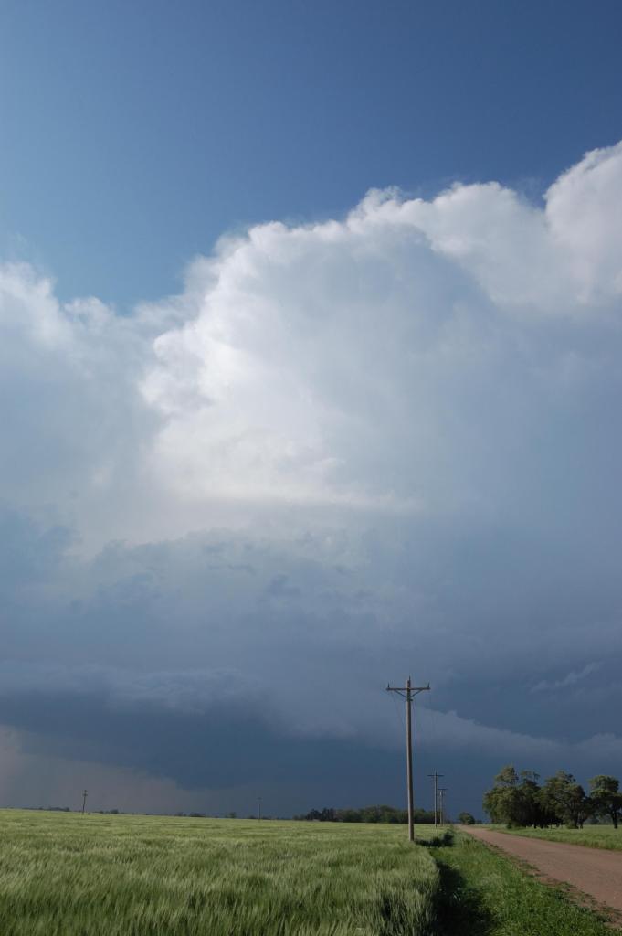
Image highlight of the year

Looking north from just west of Ponca City on 19 May at a supercell that developed behind the initial line of
storms. The structure at this point was pretty amazing despite how far from the storm we were. Several shallow wall clouds
emerged from this storm in the following 10-20 minutes as we pursued it. We eventually let it go over the Flint Hills of
extreme southern Kansas since it seemed to struggle in the post-storm air. I used MS Paint to remove some power lines in
this image.
Other chases
April 7
Targeted the Woodward-Greensburg corridor. Morning runs of the HRRR suggested several supercells may form across SW KS edging into far NW OK later in the day.
However, moisture was a slight problem. When I arrived in Woodward and looked at the data, and after talking to some other OU chasers, I decided to stay in OK.
There was a band of lift coming out of the TX panhandle, and there was better moisture in OK. Plus, a band of clouds completely eliminated most of NW OK as an
area for storms, and with strong southeasterly flow, those colder surface temps were advecting into KS to destroy my KS target. So I decided to get south of the
clearing, which quickly moved north during the late afternoon. However, by 5 PM or so, despite bright sun, it became clear that the damage had been done: the cap
won. Haven't started a season with a blue sky cap bust since 2010. As it turned out, very cool mid-level temps farther north into central KS actually allowed for
storms to form north of even my original target area - near Great Bend. One particular storm blossomed into a pretty supercell. Oh well. I hate getting pulled
farther away from my original target area.
April 9
A potent upper level storm system (the same responsible for the festivities on the 7th) finally made its way over the plains this day. Unfortunately, due to late
season cold surges and snowpack much further south than usual, a powerful and shallow cold front flew way out ahead of the upper level forcing/energy, thus
undercutting the warm sector significantly. Despite decent moisture ahead of the front, everything got shoved down into Texas. Initially I was hoping to play the
cold front/dryline intersection, but even that kept getting shoved way south towards I-20 in TX. I couldn't leave Norman until 3 PM, so I couldn't get down there in time.
It didn't matter anyway, as there was little convection of interest anywhere in the threat area. In fact, there was NO pre-frontal convection anywhere in Oklahoma. I
had to drive through the front in Lawton to actually see any storms. There was a better supercell farther south in Texas, not far north of I-20, but it didn't do much.
April 17
One of the few fun chases of the year, and still rather frustrating becase we saw no tornadoes even though they occurred all around us.
There was a solid 15% hatched tornado MDT risk, but the problems that plagued many April 2013 setups (i.e., a sharp, shallow cold air mass)
also loomed. What turned out to make this less significant of an event, however, was some backing with height in the mid levels, which made
for messy storms. We got on the main storm in southwest OK before it got interesting, but only observed occasional rotating wall clouds that
continually failed to produce. We abandoned the storm in favor of new ones developing back to the southwest when it finally produced a
weak tornado in Lawton.
The second storm we sampled between Chattanooga and Frederick became outflow dominant. Then we spotted tail-end Charlie just across the
Red River in TX. We decided to cut east on U.S. 70 at Davidson rather than cross into TX, although in retrospect, we probably would've
gotten away with that, and likely would've seen the tornado it produced just south of the river. As it was, we sat with a wonderful view off
of 70 for several minutes staring down towards the meso/updraft area, but it was getting dark and there was some precipitation that obscured
our view. We slid east with it after dark until we abandoned it near Grandview, apparently missing another tornado in the dark that crossed
70 a few miles west of Grandfield.
April 26
Left Norman at about 5:45 PM to intercept a supercell moving ESE out of northwest Oklahoma. The storm became elevated as I approached it near
Watonga. Still, it had a nice inflow tail above the surface as well as strong (but cold) inflow. Little structure was visible. I decided to
let the core overtake me on U.S. 281 a few miles south of Watonga. What followed was probably the most intense precipitation core I have ever
experienced. The onset of very heavy precipitation was rapid (from nothing to intense in maybe 10-30 seconds). The hailfall rate was also very
impressive. While even the largest stones were probably 1" at best, the sheer volume of stones was incredible. The sound of them hitting my car
(they were also driven by winds of 60 mph) was absolutely deafening. I could not see feet in front of my car! The hail nearly completely covered
the ground for 10 miles of 281 back towards Geary. I went east out of Geary towards Calumet to try to resample the core, but the storm had
accelerated. All I saw was an eery, almost heavenly, light blue glow with lots of turbulent cloud motion behind the core. Even as I sped east
on I-40 at top speed, I was only able to make slight progress on the storm. I had almost gotten ahead of it by the time I entered the western
outskirts of Oklahoma City. The storm had developed very high reflectivities in an inflow notch. I pondered driving a bit north to intercept it,
but then I filled up with gas and saw the damage the wind-driven hail had done to my tailight fascia and windshield trim. Not wanting to press my
luck any more, I continued home. The storm produced one-foot accumulation of hail in Edmond.
May 8
With much of May looking poor for widespread severe weather events, I opted to venture out on this slight risk day that never looked too
terribly impressive. However, storm-scale models were showing discrete storms developing off the dryline across the TX-OK border area in
western OK. I convinced Logan to drive down from Minneapolis to chase with me. We got on a storm just as it was developing near Elk City.
We had time to watch it for an hour or so as it barely moved and slowly organized. We followed it, then passed it near Leedey before
stopping under a gas station awning to experience the hail core. We were not disappointed - a solid 15 minutes of hail, although most of it
sub-severe. However, right as we thought it was finally over, a short barrage of around 2" stones fell. Not wanting to chase
only hail and seeing discrete storms blossoming in the TX PH, we abandoned the storm and headed towards Hollis to intercept the best looking
storm that we thought we would get to. It died well before we got there. We briefly crossed the Red River just to say we busted in Texas
before heading home.
May 18-20
This three-day stretch was the highlight of the season for many. For me, it was just another string of days I don't care to remember. On the
18th, we drove up to Greensburg and sat around for awhile waiting for storms to develop and organize. Neither Logan nor I had been to Greensburg,
so we spent some time looking at the damage from the 4 May 2007 EF5. We drove in a circle around Kiowa and Edwards counties thinking something
was about to pop, but eventually returned to Greensburg just as the storm of the day was passing northwest of there. We drove up to it, but
I wanted to stick to the south where I thought the better conditions would remain longer. This storm had a lowering, but it appeared to
struggle. So we abandoned it for storms coming east across the OK border that *sigh* had developed behind the dryline. While more intense
at the moment, they ended up gusting out. We lost data for an hour in northern OK, but then found out what we missed by leaving the previous storm.
We then got to experience a drive home commensurate with our chase decisions that day as a large heat burst enveloped half of our route home,
throwing dust and all sorts of debris and obstacles in our way from Cherokee to I-35.
The 19th seemed more promising, and also more scary since Norman was in the heart of the hatched tornado risk. For whatever reason, we
were persuaded to leave Norman around noon and go north on I-35 towards the Kansas border. We stopped near Tonkawa for lunch, then went
back south towards Enid. We should've kept going back south. Hell, we should've never left Norman. After seeing we were in the gap
in CU along the dryline near Enid and seeing storms going up north and south of us, we chose to go north towards the Kansas border, leaving
the storms west of OKC alone. We should've gone after the OKC storm. We managed to spot a brief and weak tornado from the quickly congealing
mass of storms just across the Kansas border (after having already missed the tornadic supercell beelining for Wichita), but then the
whole line went outflowly and pretty much ended our day, or so we thought. That's because we saw what was going on near OKC. Another
tornadic supercell was slowly organizing right on top of Norman, and it took a good two hours to finally pass over. While the OKC storm
went on to produce a few tornadoes, including a huge one near Carney, the Norman storm went on to produce an even more impressive EF4
tornado near Shawnee that many chasers were on. As we began our drive home with our tail between our legs, we spotted a new storm to our
north from west of Ponca City. It had surprisingly excellent structure! We pursued it, but it seemed to struggle in the atmosphere that
had been worked over by the mess of storms from a few hours earlier. Even as we abandoned that one, redevelopment continued
in a nearly continuous fashion along the cold front/dryline across N OK. We stopped again halfway home when we observed another wall cloud
pop out of a storm, but it didn't do anything. Mother nature trolled the hell out of us on that drive home. Every 15 minutes there looked
to be another interesting storm, but they were all too weak.
The 20th was pure agony and aggravation. I took this photo
early in the day as a joke given our performance the day before. I didn't follow my own advice. I should have. One very nearly could
have seen the Moore tornado from that very spot (although nearby buildings would have blocked the view...but it certainly was close
enough). We left Norman around 1 PM
as CU began deepening off the dryline to our southwest near Lawton. We got to Purcell and decided the lead storm coming up was worth
chasing. Right around the time we made that decision, the storm that was soon to produce the Moore EF5 tornado had begun developing a bit
to our west. Ignoring it for the time being, we stayed on our storm, stopping near Lindsay as it began to look visually appealing.
Sadly, it was dying on radar. While Mason and Logan mentioned a few times how good the cumulonimbus cloud to our north (the Moore storm)
looked, we chose to stay south. Big mistake. We missed the Moore tornado and the only tornadoes produced by the next storm down the line
as it took us too long to get around that storm. By the time we got on the next storm between Bray and Elmore City, it was just
finishing up its last tornadic cycle. We stayed on it for a few minutes before the final whistle of failure blew in the form of
cold outflow winds 10 miles ahead of the updraft. We briefly made a move towards another storm over the Red River, but then abandoned
as we were worried about the fate of Logan's mom, who lived in Moore and was very close to the tornado track. She was okay.
May 23
After the huge embarassing failure from the three-day stretch (May 18-20), I was about ready to call it quits for 2013. Then this day came up
in the models. It showed a very focused target area. The storm-scale models did a reasonably good job with this setup. However,
initiation was much earlier than the models predicted, and the outflow boundary punched farther west and faster than in the models.
Hence, by the time I arrived in Altus around 1:30 PM for lunch, the storm of the day had already just developed near Matador, TX, around
100 miles to my southwest as the crow files. This particular area of NW TX does not have a good road network and is about as rural as
it gets without being in the mountains (or Montana). Nonetheless I pursued this storm all the way to a point south of Guthrie, TX. On the way, the
storm morphed and shapeshifted while sinking slowly south. I was impressed enough to have even caught up with it, but 80 MPH speed
limits on all TX highways out there helped with that. I had never been in this area before, and I was a little creeped out with just how
rural it was. It got worse as I approached the system from the side since it was a very electrical system. Frequent and close CGs
were hitting all over. Given the paucity of trees and power lines out there, I was nervous about the car getting struck. South of
Guthrie I was finally able to get far enough around the side of the storm to where a supercell updraft base came into view.
However, at the same time, I was driving further into a hail core. The size was increasing uncomfortably fast. I had been
struggling with data for miles now, and at this point was completely data-dead, so I had no idea what lay directly ahead of me on
the highway. I saw a dark base and figured the system had grown another arm or another cell entirely was going up right ahead of me.
I figured it best not to tempt things and risk getting my car busted up being so far away and alone. So I turned around. I ended
up in Knox City before making the final decision to head home. Even well away from the main storm, more convection blew up to my
north as I headed north. This convection was highly electrified and was spitting out CGs everywhere, too! Again I was alone on
the highway and there was very little around me to attract lightning. I saw one teal/pink/white flash followed less than
1 second later by a huge boom (even from inside the car), telling me I had nearly been struck. That was just north of Benjamin. After
that I finally escaped the creepy hell and drove my sorry ass home. I was done for the year.
May 27-31
Like I said, I was done for the year. I was participating in this week's run of the NOAA HWT Spring Forecasting Experiment in
the weather center. Thus I missed all the action this week. I didn't chase on the 31st since I was supposed to drive to Ohio
for a wedding that day, but ended up not leaving after perceiving the great threat of a significant tornado.
At around 8 PM, the storms hit Norman, and in my last look outside before heading for the bathroom, I'm pretty sure I saw a
smooth, ghostly-teal funnel touch down around 1 mile away from my apartment.
Return to storm chasing home page.

