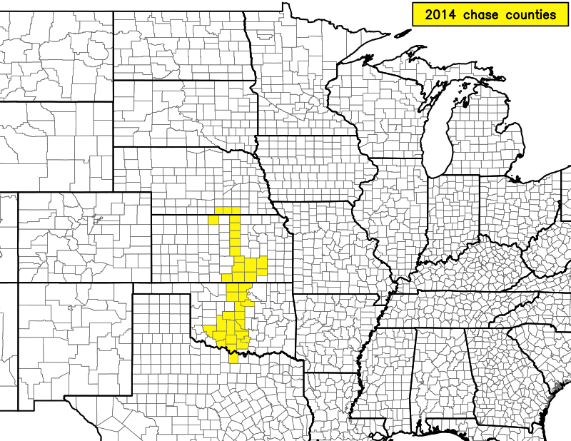
2014 Chase Season


2014 was the first year since I started chasing in 2008 that I saw no tornadoes. I saw no funnel clouds either, and only saw one or two measly weakly rotating wall clouds. I saw several supercells, however. Still, 2014 goes down as the worst year of chasing for me so far. It continues my poor performance from 2013, so I'm on a two-year streak of crappy chasing. This kind of lack of performance has caused me to reconsider how much I actually enjoy it. It doesn't help that I'm basically forced to chase alone all the time now, and chasing in Oklahoma is really not fun anymore given the crowds. I spend all of my time trying not to get run over or otherwise wreck.
Since I have little to share, I will include a brief account of this year's chases.
Cap bust on a warm front across south-central Oklahoma. Went to Waurika for the first time.
The warm sector remained capped over Oklahoma. Convection only fired along the warm front and moved off north of the front. There was sufficient, albeit elevated, instability north of the warm front to sustain elevated supercells. Intercepted one particular elevated supercell near Anthony, KS. It went a little crazy with outflow as it approached us, spawning a few gustnadoes and otherwise causing a lot of dust to be lofted around us.
That's right, my next chase was over a month after the previous one. A few setups had gone to crap in the models between then and now. This was a sign of things to come this season.
Anyway, chased a marginal event across south-central Oklahoma and extreme north Texas. It was hard to pick a storm to target since shear was barely sufficient for supercells and there were a dozen or more individual cells when I left Norman. Once I finally targeted a storm across the Red River in Texas, I barely made it there to watch it die. Then the next storm over produced a brief tornado near Burkburnett. Backtracked north on U.S. 81 to U.S. 70. The storm had decent supercell structure, but it was humid and distant. Got some shots of the base of the storm, but it did not produce any other tornadoes. It did produce a briefly rotating wall cloud just west of Waurika. I was due east of it as it headed towards me. I had to abandon my spot on the edge of a cemetary, though, as the circus train of chasers coming east on U.S. 70 neared, and I had no other escape route. Waited for the core to pass over 81 north of Waurika before heading home. Found hail exceeding golf ball size on the road afterward. Almost drove into another intense core near Duncan. Road was pretty covered in rain, but not much in the way of hail.
Of course, the best day of the year for me would come on the day that looked the most marginal in the models. Deep layer shear was only 30-35 knots, but everyone seemed to be convinced something would happen. I ended up intercepting several supercells across south-central Kansas, mostly along U.S. 400 in Greenwood County. The supercells had interesting structure, but there was a persistent mid-level cloud deck that obscured everything above the mid-levels. There were tornadoes with a few of these storms, but I managed to put myself in a location to not be able to see any of them. Apparently it's just not a good idea to put yourself immediately downwind of the updraft region anymore, as that's where I resided, and everyone else sat to the south or southwest and saw everything else. On the plus side, the crowd was much smaller than for a typical May chase in Kansas, plus storm motions were so slow I was generally able to sit along the same 15 miles of highway for two hours to intercept multiple supercells.
My first clue this was probably not going to work was that I was targeting southwest Oklahoma in June. I ended up cap busting, but I was targeting an outflow boundary that had strong enough lift to produce a consistent line of cumulus in an area of backed winds and high CAPE, so in the event something had gone up, I probably would've been treated to a nice show. Alas, that didn't happen. In fact, the action that day was across the Texas panhandle and west into New Mexico. I think there was a tornado or two out there, but nothing impressive.
This day had looked good in the models a few days prior, but kinda crapped out the day of. Nonetheless, I figured it was about my last chance, so even though it was about at my one-day chase range, I decided to go for it. At least I didn't have to do this one alone, as it was the longest chase of the year (925 miles). I went with Ben Holcomb, Andrew Newcomb, and Rachel Sager (now McBee). We flipped off the Bennington sign on U.S. 81 before getting up to Red Cloud, NE where we waited until a storm finally fired well to our southwest. Visited the geographical center of the contintental U.S. northwest of Lebanon, KS before intercepting. The developing supercell produced several landspouts while we were still too far away, although we had the storm in view (including portions of the FFD and base) the entire time. Once we finally got close enough to it, it struggled to develop or maintain supercell structure. Let it go north of Red Cloud. Ben wanted to intercept the squall line flying east out of Colorado, so we ended up waiting for it in Concordia. We probably got severe criteria wind, but no damage occurred around us. That was after midnight, and we drove home after that. Didn't get home until about 5:30 AM, making this the latest chase day ever for me.
What? A chase in December?? Yep, although it was again a marginal setup in the sense that moisture wasn't all that great and so CAPE was low. The setup was actually pretty much exactly that of a typical May dryline chase in Oklahoma, though. Just shift temperatures down 15 °F everywhere (including in the vertical). The storms were really strung out, presumably due to the poor balance between shear and CAPE. Apparently the storm I targeted produced a funnel cloud far before I got on it. It looked pretty non-threatening while I was on it. Abandoned it for a new storm to the south near Chickasha. It went on to produce a lot of hail, some of it fairly large. Spent the rest of the chase core punching it. Found myself in zero-visiblility rain and hail numerous times. The largest hail came near Will Rogers Airport, being at or larger than golf ball size.
No new dents on my car, though. Sad that was about the most fun chase of the year.
Return to storm chasing home page.