April 15, 2016 chase account

Summary: My best chase of 2016 was the first big chase of the year. I captured supercell structure that competes for career best, both in "seen" and "documented". Mother Nature was nice to me and gave me a handful of tornadoes late in the chase as well, and I played it just right so that I got a unique viewpoint of part of it.
Chase partners: none
My initial plan was to get to Amarillo by early afternoon. I figured once there I would fine tune and figure out a more focused target. After waffling around the west side of town for awhile, I decided to head towards new convection developing on the TX/NM border to the northwest. I cut up to Channing on Ranch Road 1061 and then meandered around Channing for awhile waiting for something to become dominant. After seeing a very shallow lowering appear under the otherwise featureless and high base of the storm just crossing Channing's latitude, I pursued it north through Hartley and eventually towards Dalhart. I wound around on county roads up to FMs 807 and 281. I noticed a rotating wall cloud had formed back to my WSW, so I went back west to put myself in its path. It looked like the RFD blew it apart, which was disappointing since the rotation and vertical motion looked promising up to that point.

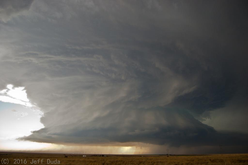
This storm seemed to struggle mightily with barely adequate moisture content in the low levels. It looked pretty good aloft, but the cloud base was so high most of the day. By the time I got up to U.S. 54 and headed northeast up to and through Stratford, I figured the day was about over other than some structure. So I sped well northeast to try to fit it in my lens. I probably could've used another few miles, but the structure at this point was just tremendous regardless:
By the time I was approaching the Oklahoma panhandle, I figured I would just continue on through Texhoma into Guymon and begin the long drive home. I stopped briefly on the north side of Texhoma and watched a strange evolution as the original updraft seemed to die off and get replaced by a flanking updraft to its west, thus discretely propagating the storm more north than anything. I caught what appeared to be a lowering struggling in the dry air 20 miles to the west. I decided I would go as far north as U.S. 412, wait for it to pass north, and then start home (assuming it wasn't going to do anything more because it hadn't given me much reason to think it would).
When I got to 412 I started getting small hail. I saw there were still some 60+-dBZ returns in the core, so combined with a scuddy lowering I figured, I'm already out here...what's another 10 miles? and went west to sample hail. After several miles the hail had stopped, but there was a suspicious scuddy lowering below the base still. Before I had time to do much, a skinny condensation finger started dropping, and rotation visibly increased. I witnessed the first tornado from the northeast:
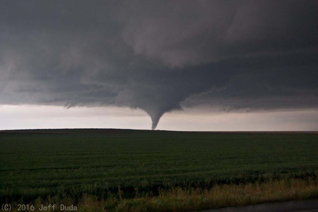
The tornado quickly dissipated, but still seeing rotation in the cloud base and recognizing my relative position to it, I decided to zoom further west for a close intercept should it touch down again. Just after I cleared the north side of the wall cloud and got northwest of it, my risk was rewarded:


The best part about this sequence was there was no one else around in eyesight while this second tornado proceeded. I only saw 3 other vehicles over about a 10-minute stretch around this time, and only one was a chaser. I thought that was very unique considering the numbers I had seen earlier in the day. It's also pretty much unheard of in Oklahoma anymore. These two tornadoes were also my first in the panhandle.
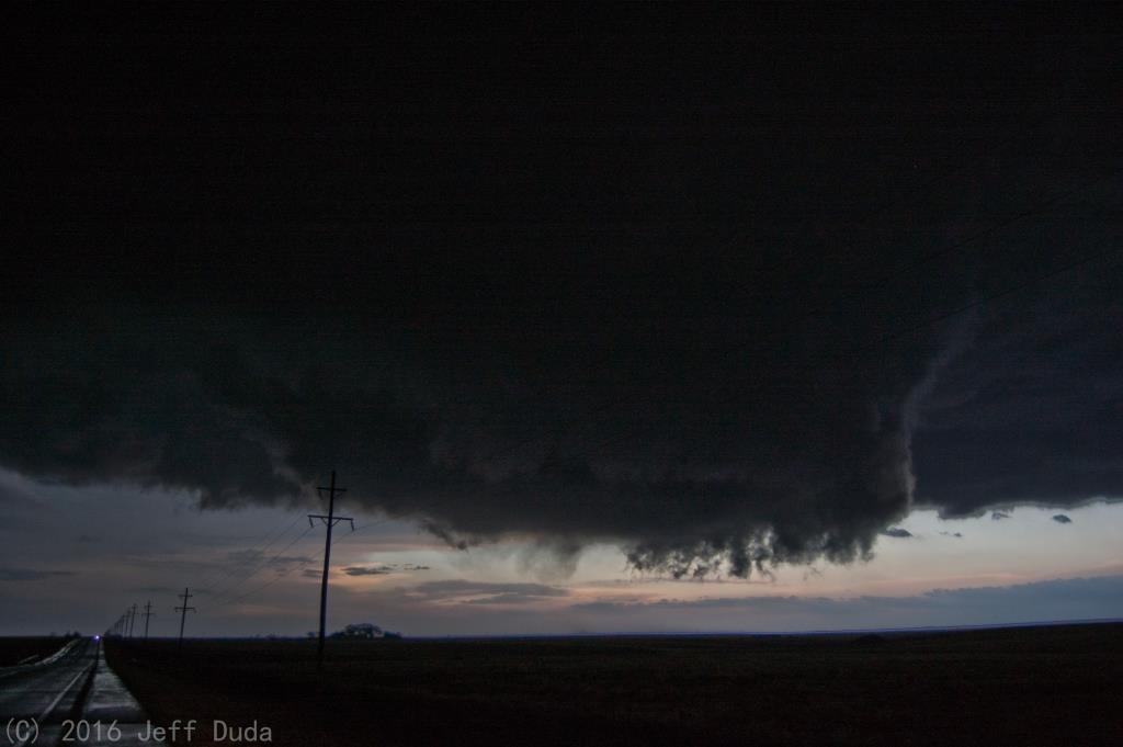
I crept slowly back to the east to keep pace just behind the west edge of the bear's cage. I had front row seats to the sudden core dump that occurred right in the middle of the wall cloud. While moderate rotation continued under the wall cloud, no obvious tornadoes appeared to occur. I saw very faint wisps along the ground once or twice, but it appeared the storm was still struggling to birth a full blown monster given the low-level shear at the time. I can only imagine how spectacular a show may have occurred had mid-50s dewpoints made it into the Oklahoma panhandle.
Anyway, I skirted the circulation that evolved as it crossed 412. The circulation became extremely high-contrast rain-wrapped. The transition from zero-visibility precip to clear air was amazingly tight. I could see individual wisps or sheets of precipitation orbit around the south side of it. Standing water on the road made it very easy to witness the wind direction turn from northwest to westerly to southwesterly to southerly in a span of no more than a mile. I passed a single power pole that had been bent at about a 45 degree angle, which supports the notion that this circulation was only very weakly tornadic if at all (it could've just been an inflow jet or something that did that). I pursued it north on OK-95 a few miles before turning around as I did not feel safe penetrating the liquid circulation in increasing darkness. Considering how long of a drive back home I had, how dark it was getting, and the rush from what I had just witnessed, I was content dropping the storm even if it did go on to produce other tornadoes.
I did capture a fair amount of video from the chase. Unfortunately my camera defaults to autofocus every time I turn it off or take out the battery, and I didn't think to switch it back to infinity before recording, so much of my video is plagued by the classic focus-on-the-raindrops-on-the-windshield issue. I also forgot to record the sequence where I passed around the rainy circulation.
Return to 2016 - chasing home page