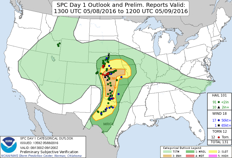
Summary: see that single red dot (tornado report) in SW OK? Got that one, but it took some work.
Logan flew in for the weekend for this one. In the days leading up it was looking like veer-back may destroy the day, but the NAM came in and suggested no such issues. I was liking the area of SW/SC KS, but 24 hours before the event, the CAMs started blowing up a lot of storms in SW OK, where I was getting pretty tired of chasing already. All but two of my chases so far in 2016 had been to that area, and I was 0-fer in SW OK up to this point in 2016. That changed today.
Chase partners: Logan Karsten
We compromised on a target in west-central Oklahoma and left Moore around 10:30 AM, stopping by the TWISTEX memorial near El Reno on our way to pay our respects. We lunched in Weatherford, then settled along a pull-off along U.S. 183 just north of Arapaho, arriving by 2 PM. This was surprisingly early for us to be in our target area. In my chasing history, I've almost never arrived in the target area more than an hour before initiation. Anyway, we baked under the sun for a good 90-120 minutes before anything happened. We both actually went for a run along the pull-off. I ran at least one mile!
We went back to Clinton to grab some water after our workout, then returned. Shortly after returning, we finally spotted developing agitated CU up and down the dryline statewide. The most vigorous development was concentrated across far SW OK, however. There was some development occurring to the northwest, also, but we eventually opted for the southwestern target.
Unfortunately, 'S'-shaped hodographs made an appearance on this chase. See below.
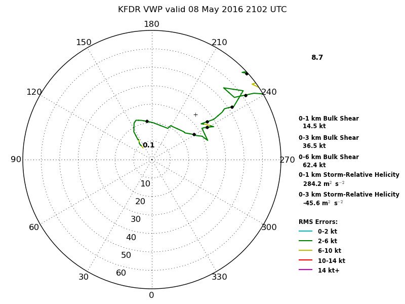
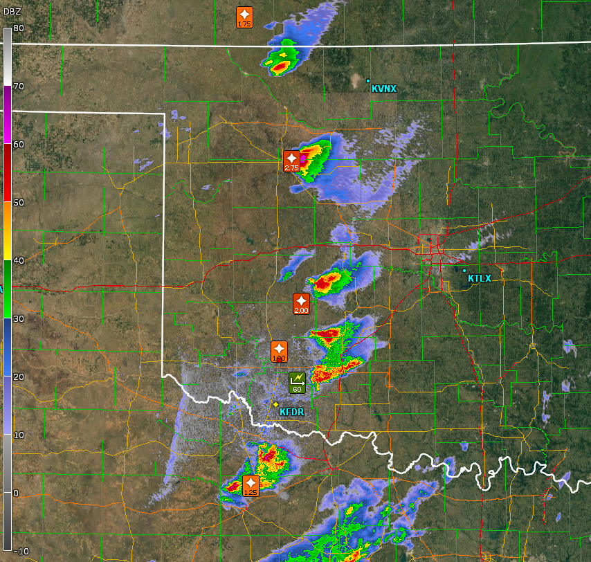
It wasn't so much of a veer-back as it was strongly veered and weakened 700 mb flow relative to the rest of the profile. Hodographs across W OK featured counter-clockwise turning shear vectors that promoted left movers over right movers. A storm needed a SMV of nearly due east in order for cyclonic rotation to survive. The first few storms were moving northeastward, and thus left splits became dominant and right splits noticeably struggled. On the way towards one storm to our southwest that appeared to have rooted and was turning right, we passed in front of a left split that showed impressive structure for an anticyclonic storm. That left mover trekked all the way to the KS-OK border by the end of the day, whereas the right split indeed died as we got to it. There were additional storms to the south and southeast of our storm, so the stream of unstable low-level air was also being cut off by storms upstream. Unfortunately we were already a good 40+ miles (as the crow files) behind the southernmost storm, which was the only one still ingesting undisturbed warm, moist air, and actually had turned pretty hard to the right and was moving nearly due east. It also had thrown off a left split that was raining tennis balls on its way across W OK, partially blocking a route to catch up.
I figured we were done at this point. We had two hopes remaining, but I figured both were low probability:

The drive through Lawton was quite hazardous. Outflow winds and precip rates increased significantly as we approached I-44. Hydroplaning became a serious detriment to quick progress eastward. Logan's skillful driving got us through, though. The best route took us on a hook slice, which we began in earnest as we left I-44 at OK-7 and headed eastward. It took a long time to get through the hook despite its appearance on radar. We must've been moving right along with it for awhile. We had to take it slow as we encountered occasional damage and strongly wrapping rain curtains immediately in front of us and to our right. Visibility was very poor during most of this stretch, so we really couldn't tell if we were driving into a tornadic circulation most of the time. Winds were frequently switching between northwest (RFD) and north/northeast (inflow). Wind speeds were strong enough to suggest there was something present in the rain not far away, strong enough to force us to proceed with caution. Finally we spotted daylight to our east and made a quick dash to pass to the north of a ball of precip that appeared to be rotating immediately to our south.
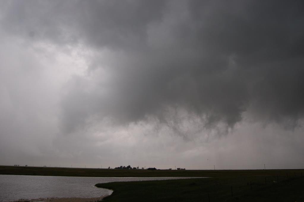
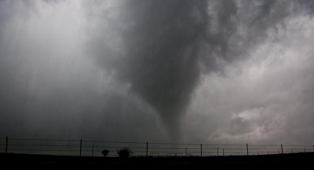
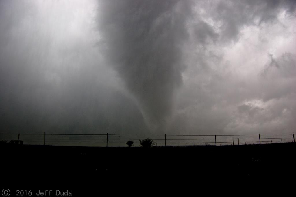
The environment inside the hook was disappointingly calm. No big wall clouds or strong inflow were noted. Nonetheless we inched east, keeping an eye on the intermittent circulation to our immediate southwest. After a few miles a concentrated area of rotation finally emerged, and I could tell it was strong enough to put down a tornado. After a minute or two a ghostly white funnel emerged from the brightly lit abyss above it. The tornado was probably within a mile, but it was dead quiet. The tornado was small and spits of heavy rain made viewing it less than pleasant, but regardless we were able to watch it writhe eastward. It had impressive rotational velocity aloft, especially as it roped out. This was one of the prettier rope stages I had ever witnessed; it helped being so close. Unfortunately the tornado only lasted 3 or 4 minutes and we lost the very last bits of it in the trees as we moved east to reposition. Still a pleasing event considering we thought we had busted a few hours prior.

The storm gradually weakened after the tornado, as it was moving into an area with a strong cap.
Return to 2016 - chasing home page