
|
|
|
|
|
|
|
|
|
|
|
|
|
|
|
|||||||
|
|
|
|
|
|
|
|
|
||
Atmospheric Circulations
An animation
of the cloud motions reveals motions of the clouds in the
tropical regions to be from east to west, while those in middle latitudes were
from west to east. Because the preceding description of the global circulation is
somewhat idealized, there may be occasional exceptions to this simplified
picture of atmospheric motions.
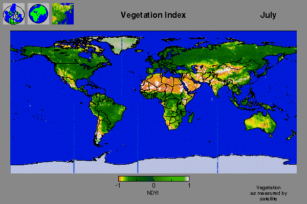
Rising air in the tropical regions may reach altitudes of 10 km or more. As this air rises, it cools, and the further it rises the more it cools. In fact the coldest temperatures in the lower atmosphere are not over the polar regions but over the tropics near the base of the stratosphere. Intense precipitation resulting from this rising air eliminates most of the moisture, so this air moving toward the poles is very dry. As this air sinks in the high pressure belts at 30° north and south, it is compressed and warms, just as air in a bicycle pump is warmed by compression. This warm, dry air produces a cloud free environment with sunny dry, even desert, climates at these latitudes. A quick look at the vegetation maps [Figure 10 (July 1995)] for the planet shows the paucity of vegetation at these latitudes.
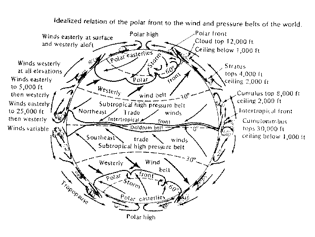
The weather and climate at midlatitudes is dominated by the motion of the westerly wind belts in the North and Southern Hemisphere, as shown in Figure 11. This region is the battleground between cold air masses originating in polar regions and warm air masses arising from the tropics. The boundary between these two air masses at the earth's surface defines the position and character of the weather fronts (cold fronts, warm fronts, stationary fronts). At the tropopause, this boundary marks the position of the jet stream, a high-speed current of air moving generally parallel to the air-mass boundary from west to east. Cold, dense polar air occasionally sloshes toward the Equator, dragging with it the frontal boundary (cold front) at the surface and the jet stream aloft.
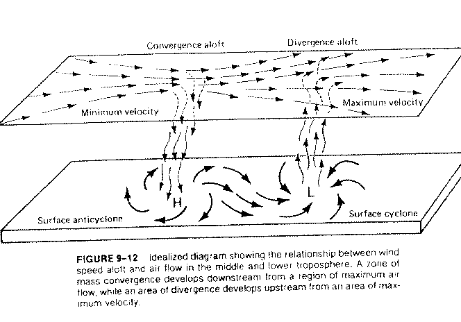
The jet stream is linked to surface weather patterns through horizontal convergence and divergence patterns. A sketch of the jet stream shows that the streamlines come together in some regions leading to higher speed flow. These regions are linked to downward moving air at midlevels and high-pressure zones at the surface where air is turned by the Coriolis force to form a clockwise rotation. On the other hand, regions of divergence aloft tend to draw air upward from the surface forming low-pressure centers at the surface, as can be seen in Figure 12. If this rising air is warm and moist, it produces cloudiness and precipitation normally associated with low-pressure centers. Forecasting the weather is then an attempt to forecast how these low-pressure centers develop and move. Because surface weather features are very strongly linked to the upper level flow, the first computer forecast models developed by applied mathematicians and meteorologists were designed to predict the characteristics and movement of the "middle" of atmosphere, at 500 millibars or 5-6 km above the surface. Patterns and movement of this region give strong clues about weather at the surface. Depictions of global precipitation patterns, with animations, are available from the NASA Goddard Laboratory for Atmospheres Global Precipitation Analysis.