 |
 |
 |
 |
This would be the last straw for me for the traditional 2010 severe weather/chase season. I saw the potential of the day beforehand, but when I woke up (late, like 11 AM) and saw the progs, I realized I would pretty much have to leave immediately to get up to Sioux Falls as a starting point, with a target north and west of there. I just didn't feel like it, especially after the past three pretty lame chases.
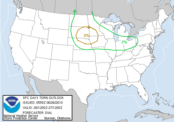
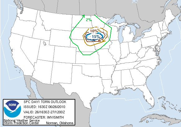
I went to my office to do some research work. It was then that I got a call from Adam asking if I wanted to go chasing. He mentioned a tornado watch that had been issued for the target area. I looked at it and my jaw dropped. The watch had probabilities of 80% and 50% for at least 2 tornadoes and of at least one significant (EF2 or higher) tornado, respectively, occurring, (I call it an 80-50 watch)! What?! That's PDS caliber! Not only that, but SPC had upgraded its Day 1 outlooks to include a 15% hatched tornado probability. Check out the evolution of the Day 1 tornado probs below.
|
|
|
|
Perhaps SPC forecasters were jazzed up after the previous night's event which featured a tail end Charley storm that produced an EF4 tornado near Sibley, Iowa at 10:00 PM. I was rather amazed to see this. I didn't see how a watch with such high probabilities was warranted given the forecast setup. Sure, instability was going to be very high, but deep-layer shear was not very strong where instability was very high. Plus there was a pretty stout cap moving in where the best instability was located (see evolution of 700 mb temps in this loop). Pile on top of that the fact that low-level shear was minimal. So I'm not really sure why a watch with such high tornado probabilities was issued in the first place. I didn't buy it. However, it was when I checked the HRRR that I became interested in chasing. Several consecutive runs showed an isolated storm that had the shape of a supercell in progress in/near Kossuth County at 2300Z and 0000Z. When Adam and I talked on the phone, we decided that we were ONLY going to target that area, assuming those model runs verify. The HRRR had been pretty good all season long with things like this, so I saw a reason to chase suddenly. Thus Adam and I headed out with Ryan at around 2:00 PM northbound on I-35.
On our way north towards Algona (the county seat of Kossuth County), further HRRR runs continued to show the storm in the target county as well as developing a storm east of Sioux City, also discrete and supercellular looking. My morale stayed high until we got going west on U.S. 18 towards Algona. We had driven under a deck of cumulus/stratus clouds that were either high-based or simply located in the mid-levels. Even though surface temps had climbed to respectable values, the clouds were keeping them from climbing up to near-convective-temperature values. Thus I knew that unless the boundary sank south or the clouds cleared (or the cap weakened), there would not be any surface based storm development in the area in the next few hours. So there went the Kossuth County target. Surface conditions and CAPE were much better near Sioux City, but the cap was stronger there and shear was weaker, so I was pretty sure that target wasn't going to work out either. We just kept going west until we found something worth going after.
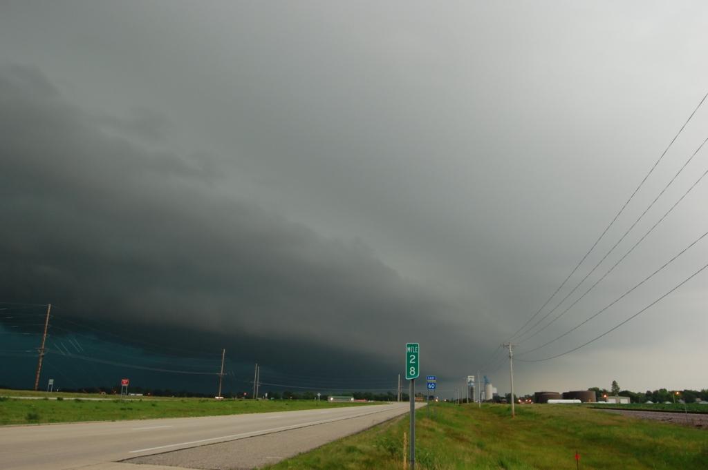
As we continued west, storms began developing in southeastern South Dakota ahead of the cold front and in a region of synoptic scale lift and less of a cap. These storms were 150 miles to our west, so we were a long way away from making a play on them. Many of them began to grow into big, wet, HP supercells. One was discrete to the WSW of Sioux Falls and ended up going tornado warned. It did produce a brief tornado before it began to gust out and turned into a cell with high wind at its leading edge. We ended up in Luverne, MN to eat at Taco Johns (to try to force some luck). We left Luverne and headed back east 20 or so minutes before the previously mentioned cell made it to town. It was joining a big line at that point anyway and no longer posed a tornado threat. We only saw one cell to the northeast heading for Windom that was still semi-discrete and showed signs of rotation at times. We made it to Heron Lake on state highway 60 before we stopped and watched. The storm had pretty much gone linear at that point and had little more than some CGs and a shelf cloud to show. A LEO walked up to me and talked to me about storms and weather. He seemed very excited about severe weather and mentioned being on the storms last night. He told me that if he suddenly tore off in a cloud of dust it was because someone reported something or a tornado warning was issued. The storm we were on then was never tornado warned.
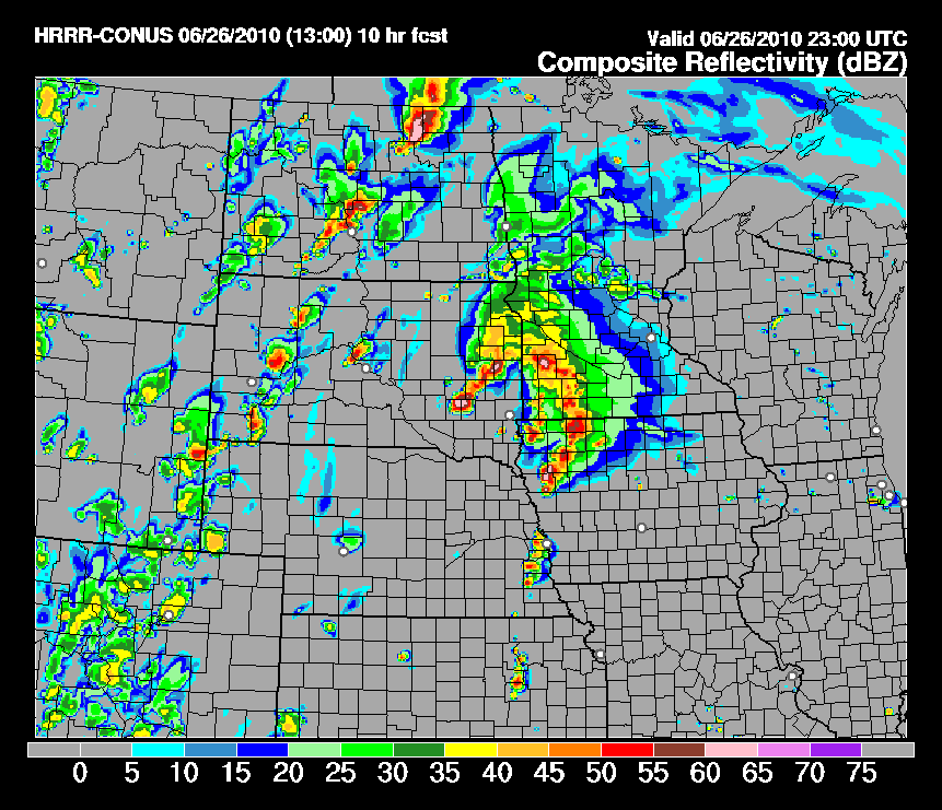
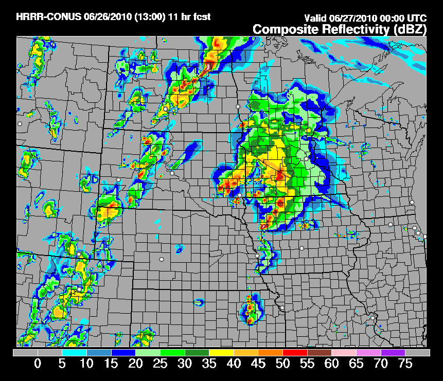
It was now after 00Z and the HRRR's prophecy of doom had proven predictably wrong. See the loops I made below. They show the forecast composite reflectivity for 23Z and 00Z from various model initiation times during the day and end with the observed regional radar. Talk about model failure.
Facing another pretty lame chase unfolding, we decided to quit while we were behind and just mosey our way home. We began heading south. However, before we could even make it back to I-90 a storm just to our southwest (really just a part of the line) went tornado warned. We were in a decent position to see it if we could blast south fast. The road network required us either to punch it back through Worthington or flee south, then east several miles before we could get south again to stay ahead of it. Figuring that the line would start to speed up we decided to take the south and east option. We might've seen a wall cloud from several miles away at times, but we couldn't confirm anything, even though a few tornado reports came from that area. Oh well.

We ended up getting chased by the whole mass down to Spencer where it finally overtook us as we stopped to fuel up. Ryan was driving and as he opened his door to get out a wind gust of probably 40 MPH or so pulled on the door so hard it caused him to rip the door panel off by just holding his arm steady! That door panel was halfway off already, but it was funny to see it happen. It ended up bending the locking pin for the door so that was fun to deal with until I got it fixed.
We continued south towards home as we noticed a tail end charlie storm near Sioux City that had separation from the rest of the line. Hoping for some magic in almost the same location as the night before and with the same setup, we detoured west towards Cherokee to see if anything would happen with it. Nothing did as the storm lost some strength and shape. We turned around at Aurelia on state highway 7 and drove home. The outflow boundary of the system stayed ahead of us during most of the drive home. In fact, it wasn't until we reached Fort Dodge that we finally got back ahead of it. It was insanely far out in front of the leading edge of convection, and I figured that would cause the line to die quickly, before reaching Ames, in fact. Somehow, it didn't, and it was a rainy night after we got home.
I was rather angry at myself for getting fooled by SPC and the HRRR and chasing on a day I otherwise wouldn't have. As it is, only two tornado reports occurred inside the watch area while it was in effect (one of them is not on the SPC reports page for the day: the one Andy G. got 45 seconds footage of)! The watch may have verified for severe hail and wind, but it was a total failure for tornadoes.
Return to 2010 - chasing home page