0-1 km shear
 |  |
 |  |
This chase was sort of disappointing, but was significant due to the tornado that struck Norman.
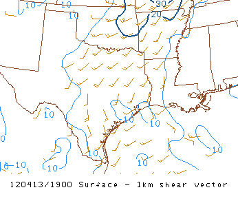
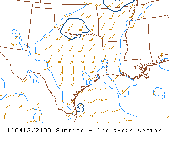
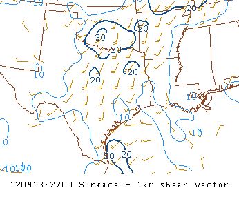
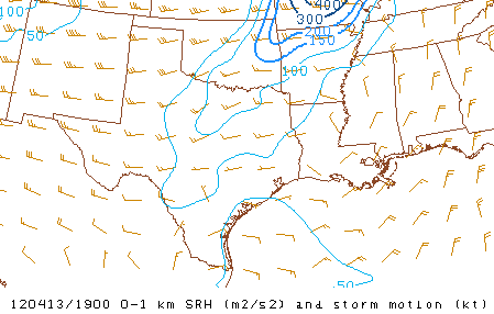
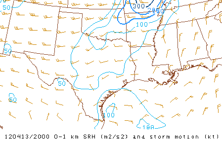
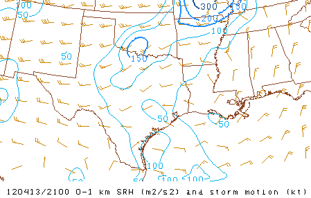
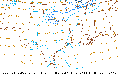
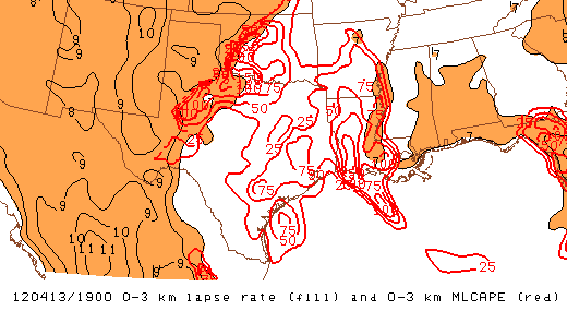
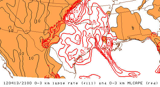
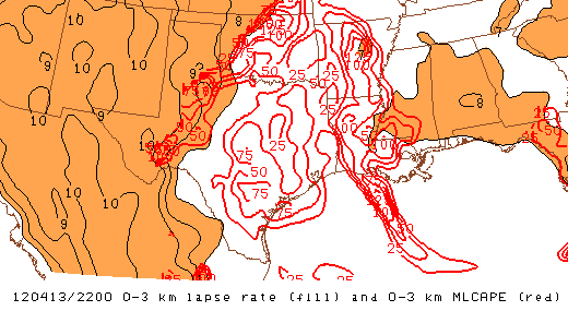
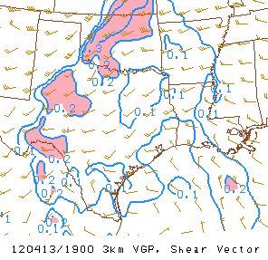
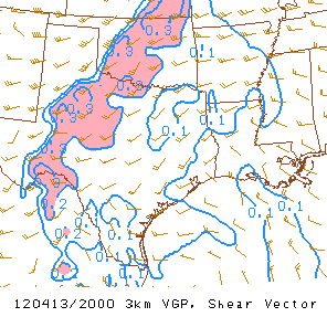
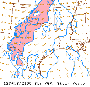
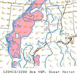
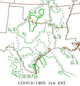
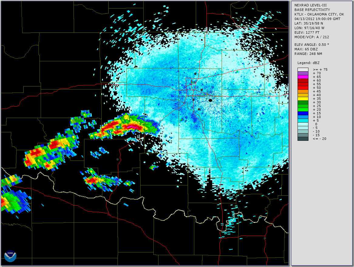
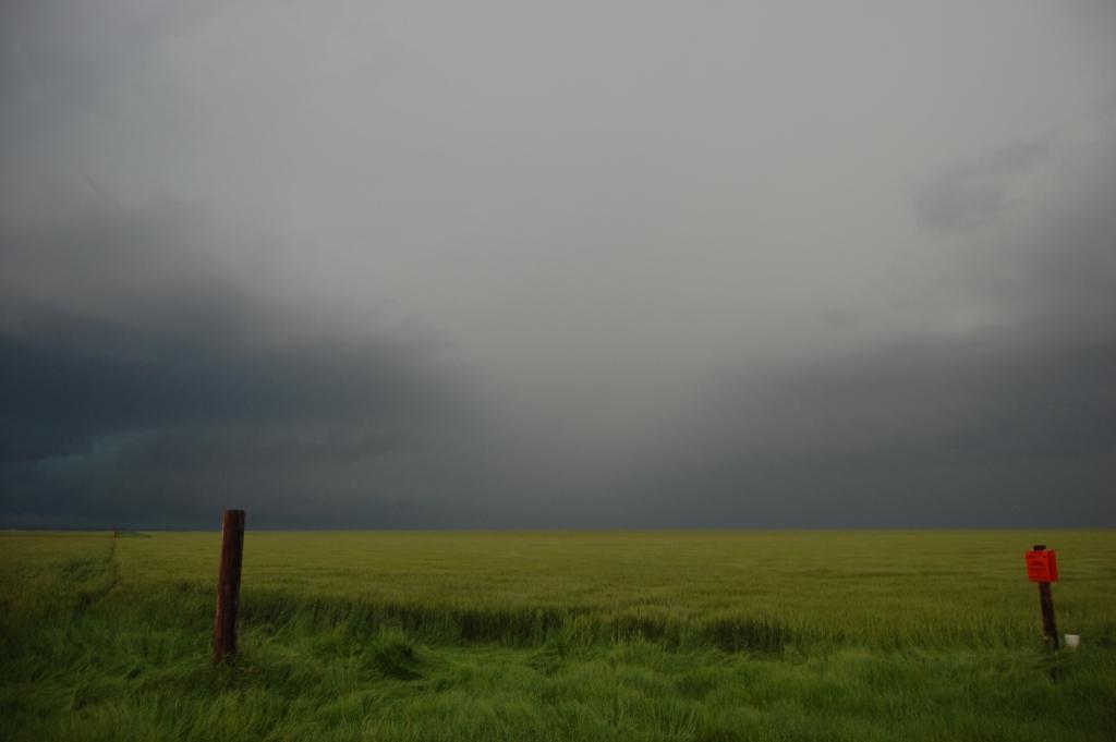
I left the National Weather Center around 1 PM with a few other OU School of Meteorology grad students. Initially they wanted to head all the way west to Hinton or thereabouts. I convinced them to turn south from I-40 at around El Reno to head towards Chickasha. We stopped briefly in Minco before continuing south. Between Minco and Chickasha we passed under a storm that was very unorganized and had cold outflow. Once we got south of the precip core, we were greeted by a long, shallow shelf cloud, and we found ourselves in cold outflow for a long time, well after we had moved west from Chickasha. We saw a helicopter flying around the storm, though; probably one of the media helicopters. Parameters were mildly supportive of supercells and tornadoes at the time. I'll let you, the reader, be the judge of that (see plots below). Keep in mind that at the time of this intercept, it was probably around 2:30 - 3:00 PM, and we would only have access to the 19Z mesoanalyses. The tornado hit Norman right around 4:00.
| |
| |
 |  |
 |  |
 |  |
 |  |
 |  |
 |  |
 |  |
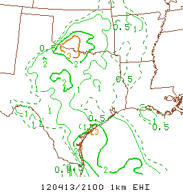 |  |
More graphics can be found here. What's clear is that the tornado potential could not be discounted. However, the parameters kind of "snuck up" on us, generally not exceeding some rough threshold values until the hour the tornado occurred. Given the 20-30 minute lag between analysis valid time and the time when the graphics first become available, it made anticipating what this storm would do more difficult. Also, one cannot ignore the fact that the SPC mesoanalyses, which were produced by the RUC surface objective analysis system (SFCOA), contain errors, some of which may be significant. For more reading, see Coniglio (2012, WAF). We definitely overlooked the environment this storm was moving into. However, it seems rare for a storm which is outflow dominant to become inflow dominant and produce a tornado. Obviously it is not impossible. Digression aside - back to our account...
We had stopped in Apache to wait. The initial convection that had gone up wasn't looking very well organized and was cluttering up the area, working over the atmosphere and essentially screwing things up. We had our sights set to the southwest where the atmosphere had been stirred up less. However, it was 3:30 or so and the atmosphere needed time to recover. Using our smartphone radar apps as we waited, we watched the storm we had just driven under head for OKC with maybe some large hail as he main threat. I got a call from my wife. She works in downtown OKC and had left her phone at home that morning, but was calling me using a co-worker's phone. She got off early (at 3:30) and asked me about the storm. I told her that if she could find a way home that was east of OKC then she should be okay beating the storm out of OKC and avoiding hail. At the time I had little reason to suspect the storm would become tornadic and turn for Norman. Almost as if on cue after I hung up, the next several scans showed the storm start to grow a hook and develop rotation as it trekked across I-44. As more scans came in, it became more and more apparent that the storm was organizing, especially as it began to slow down and make a hard right as it was just west of Norman. The four of us kind of watched in shocked disbelief as the rotation tightened and intensified just as the couplet moved into Norman. The Norman WFO finally issued a tornado warning just before the storm moved into town. It's almost like they knew something we didn't know (either that, or they were just covering their asses as a storm with rotation moved towards a highly populated area).

BULLETIN - EAS ACTIVATION REQUESTED
TORNADO WARNING
NATIONAL WEATHER SERVICE NORMAN OK
359 PM CDT FRI APR 13 2012
THE NATIONAL WEATHER SERVICE IN NORMAN HAS ISSUED A
* TORNADO WARNING FOR...
CLEVELAND COUNTY IN SOUTH CENTRAL OKLAHOMA...
* UNTIL 430 PM CDT
* AT 355 PM CDT...NATIONAL WEATHER SERVICE METEOROLOGISTS DETECTED
A SEVERE THUNDERSTORM CAPABLE OF PRODUCING A TORNADO. THIS
DANGEROUS STORM WAS LOCATED NEAR NEWCASTLE...MOVING EAST AT 25
MPH.
* LOCATIONS IMPACTED INCLUDE...
NORMAN...STELLA AND LAKE THUNDERBIRD.
THIS INCLUDES INTERSTATE 35 BETWEEN MILE MARKERS 108 AND 115. (I live one mile east of I-35 at exit 110.)
...
$$
You can imagine the sense of dread that overtook us all as we watched the radar and social media outlets for any signs that a tornado struck Norman. Within a few minutes, the Facebook and Twitter updates came: damage at 24th Ave. and Lindsey St. in Norman. I was only somewhat relieved by this notification since the location was roughly 2 miles south and 1 mile west of my apartment. Given the likely east or northeast motion vector, my apartment was not likely to be in the direct path of the tornado. However, Sooner Rd. was a great alternate route between OKC and Norman that was east of I-35. The intersection of Sooner Rd. and Robinson St., where my wife could be at that time, was in the direct path. Since she left her phone at home and I presumed she was driving home, I had absolutely no way of warning her. I could only hope she was listening to the radio and heard reports of the tornado in Norman and would be smart enough to stay away from town, and more specifically, to keep her eye on the clouds and bail if things started to look bad.
I decided to try calling a co-worker of hers that also lived in Norman. I reached him and he relieved me greatly by telling me that my wife had decided to drive behind him and that they decided to stop near I-240, well outside of the path of the tornado. They were both fine. I was okay after that. However, two of my partners had similar close calls and it took some time for them to determine the whereabouts of their loved ones and homes. We found out eventually that everyone was okay and all residences were unharmed. Relieved, we finally decided to pick back up on our chase. Some time had now passed so that we could make an informed decision about our next move. The last storms in the first cluster had passed to our northeast and new storms were developing near the SW corner of the state and into the TX panhandle with an open, although mostly cloudy, environment between us and them. Therefore we decided it was time to move west.
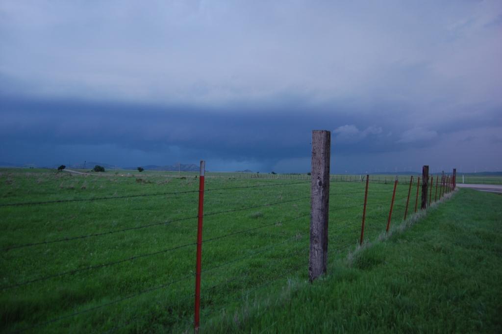
Although I had been to southwest Oklahoma a few times before, I was still amazed by the terrain. Aside from the Wichita mountains that are clustered in a region just west of Lawton, the area is as flat as a pancake. However, random hills/mountains a few hundred feet tall can be found scattered about within about 30 miles of the main area near Lawton. We had to drive across the northern part of the mountains on our way west towards Roosevelt. We turned north on U.S. 183 towards Hobart to close in on our first target storm. It didn't appear overwhelmingly organized, but it had that "shape" and it was discrete. We found a roadside pullout and pavillion to stop and shield us from the rain.

The storm showed no signs of becoming better organized as it approached, and more storms were developing and intensifying to the southwest of it, so we bailed on it and headed south and west. We paused just north of Roosevelt for a few minutes. We could see the base of the next storm down the line, miles to the southwest. It looked meaty, but also kind of scuddy looking. In fact, what some interpreted as a mesocyclone/updraft, I thought looked more like a massive shelf cloud. Given the worked-over atmosphere, which simply had not had enough time to recover, I figured all of these storms would be outflow dominant.
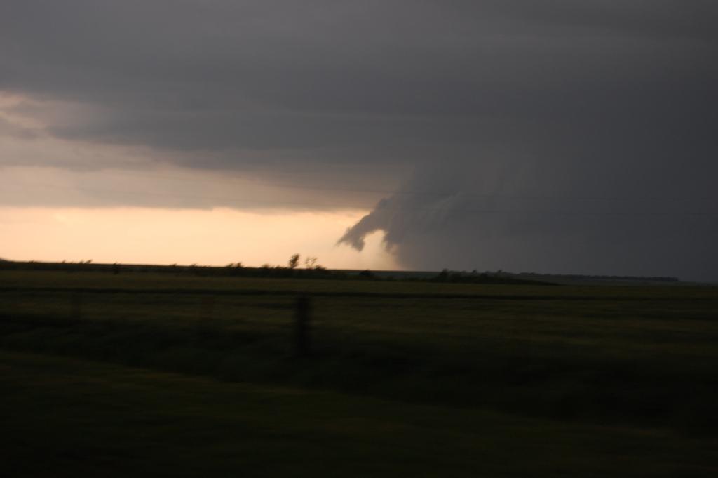
With nothing else to target, however, we moved farther south and west, reaching the turn from south to west on state highway 19 before stopping since our route further on would be cut off by the storm. We were greeted by quite a sight:
No, not the car...
This was no outflow dominant piece of crap storm!
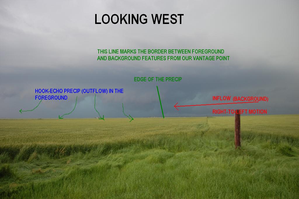
It may not be obvious from the image above, but looking to the west, there was clearly an inflow notch in what was really a
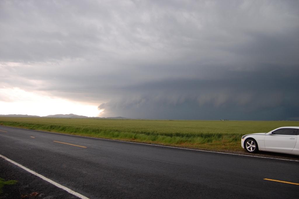
developing HP supercell. What we were seeing from afar was the very precip-laden RFD - the fat, wet hook. The storm was
bearing down on us and we had only one escape route, but we had some time to watch before needing to flee. We watched some
right-to-left motion going towards and behind the rain shaft due to our west develop and intensify, becoming quite violent from
our vantage point. Rain likely obscured our view of much of the low-level mesocyclone, but it looked pretty ominous. There was
likely a rapidly rotating wall cloud buried in the precip. Possibly even a tornado. We stayed as long as we could, but noting a
ghostly white/yellow shaft in the vault region begin to move over the road to our north (our escape route), and using a vehicle we
didn't want to be hammered by hail, we decided to bolt.

We took some nickel sized hail on our way out, but otherwise the rest of the chase was pretty uneventful. Due to the mountains, the road network made it very difficult for us to stay safely ahead of the storm. The high-precipitation nature of it also made viewing any tornadoes very risky, as we would essentially have to drive into the precip-laden RFD to have any chance. We tried maneuvering generally south and east. Eventually we wound up on U.S. 62 heading east out of Snyder. We had mostly lost any decent view of the storm and even from a distance it appaeared to be less organized than before. The outflow was kicking out so far ahead to the southeast that our view was completely blocked even a few miles south of Roosevelt on U.S. 183. The storm did produce at least a few weak tornadoes, but the people that saw them were indeed inside the wet RFD and some of them had to put themselves in danger to see the tornadoes.
We ran into data issues as we headed east on U.S. 62 towards Lawton. Once we got data back, we saw the storm was still alive and well apparently, possessing a hook that wasn't as fat as before and as well as strong rotation. Despite the fading light, we decided to try to re-engage it as it emerged east out of the Wichitas. So we went north from Cache to cut through the Wildlife Refuge. We continued north and west on state highway 115 to get as far north and west as we safely could. The storm was cutting off the route to get back to 19. We probably would've had a better end to the chase if we had tried to get to 19 because apparently the storm produced another set of tornadoes at around the time we sat watching it. However, the storm still was of the HP nature and it was impossible to see anything through the precip, as the image below shows.
We headed back towards Norman. I had a sore-throat and a cold coming on, so I was exhausted, but excited to get home. On the way up I-44 we observed three supercells rage on just to the north and west of the interstate, generally heading for Norman. We figured it would be a very loud and bad night in Norman as it seemed like each one would strike the city. It was then that one of us said that I-44 is basically an avenue of death for the greater OKC area because every time a storm moves up the road, it seems to spell danger for one of OKC, Moore, or Norman. The road defintely lived up to its name today.
Fortunately the three night time storms each weakened or veered away from town by late night, and none hit.
Phew!
Return to 2012 - chasing home page