Summary: Despite having an overall good year, 2015 started off with several frustrating chases with missed tornadoes. This chase was worthy of including because my image of the year was obtained this day. You'll see.
Chase partners: Mason Rowell and Petar Bukovcic
Aimed for the Childress-Amarillo corridor. I wasn't too excited about the idea of having to go to damn near the New Mexico border, but I had a feeling forecasts of initiation there would verify. By the time we got to Childress it was clear the area I hoped to chase in (NW TX and SW OK) was going to remain capped despite some heating due to the presence of a cold pool from morning storms over OK. The accompanying OFB also served to limit or eliminate any southerly component to the winds with access to the good moisture farther south, thus keeping theta-e down and helping restrict any development in the area. We moved west towards Silverton as the "storm of the day" developed southwest of Amarillo. I found it humorous just how long that storm basically sat in one place. In the two hours we spent approaching it from the east, it moved probably no more than 15 miles eastward, staying in Deaf Smith County the whole time.
We came to our first observation point WNW of Happy along F.M. 168 just south of the Buffalo Lake National Wildlife Refuge. In retrospect, it might have been better if we had headed west out of Tulia towards Dimmitt then headed north instead of going north first. There's a pretty bad break in the road network in the area limiting east-west travel between U.S. 385 and 87 that we were unaware of until we got out there (first time chasing in that specific area). Regardless we had a very open view of the storm to our west as it finally began to pick up some forward speed and move southeast. We probably were there for over 30 minutes watching it push out a lot of dust and outflow along the southern edge with constant, sometimes very low, scud closer to the precip core. However, it never appeared to rotate at the low levels. Eventually we had to move to stay out of the core, and we were pretty much fleeing for the rest of the chase after that point.
The image below shows a summary of what we saw at this position. Apparently David Drummond was close enough that he saw a tornado somewhere in this at some point. I don't know when it was compared to my images, but it had to have been just a dust whirl. Although there were plenty of lowerings (some very low) I never saw anything obvious.

The storm accelerated as it approached Happy, so we went more south than east to stay ahead of it. We ended up in Tulia, then headed back towards Silverton before diverting south on F.M. 378. Many miles south along that road we decided we'd had enough of messing with the storm - it was clear to us it was no longer a reasonable chase target since it was losing its supercellular characteristics and was more of a wind-blown hail threat than anything at that point. So we decided to let the flaring southwest flank of the storm overtake us. It was pretty uneventful.
Figuring the chase was over at that point, but having our easterly route home blocked by the storm, we meandered while waiting for a gap to open up over F.M. 97 to get off the caprock. We noticed the Plainview storm moving due east to our southwest, so we decided in the meantime to have a look at it. Zooming south on F.M. 378, we got around the core a few miles north of Lockney. What we saw disgusted us: it looked like a cold pool had already formed and was miles ahead of the precip core, as we could see scud rising in the shape of an arcus cloud into the updraft base well south of the edge of the core. We saw a snaky needle like scud tag, but perhaps someone thought that was a funnel cloud. idk, it was weak if anything. So we turned back around to head towards F.M. 97.
Upon reaching TX-207 the storm went tornado warned, so we detoured south towards Floydada. We got south in time to see some very cool supercell structure without any clouds around it just north of Floydada. We were looking into the region where a tornado would most likely be found if there was one, but it was getting dark and contrast was poor. We saw lots of lowerings/wall clouds, but could never make out any funnels or tornadoes, nor did we ever see any dust swirling around on the ground. This was right at the time Roger Hill dropped an SN report of a tornado. Apparently we were either too far away or just blind, idk. Couldn't have possibly been long lasting, fully condensed, or large. Anyway, the structure on that storm (which was not the storm I had previously called the storm of the day) ended up being the big reward on this chase. I only wish we had been 5-15 miles further east/southeast so to have gotten a wider view of the structure.
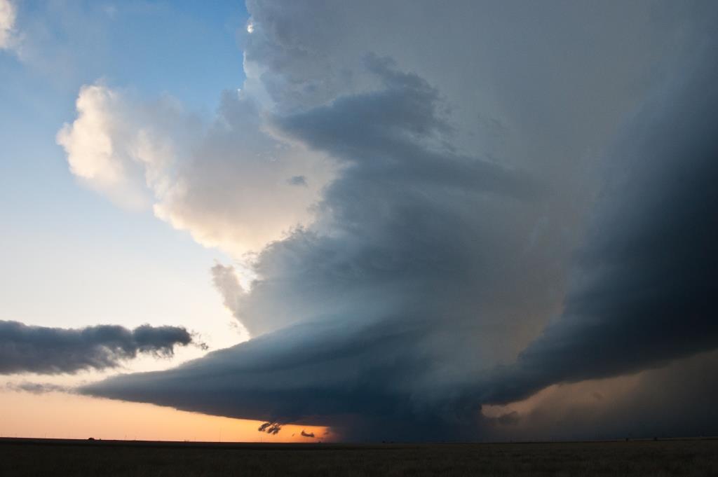
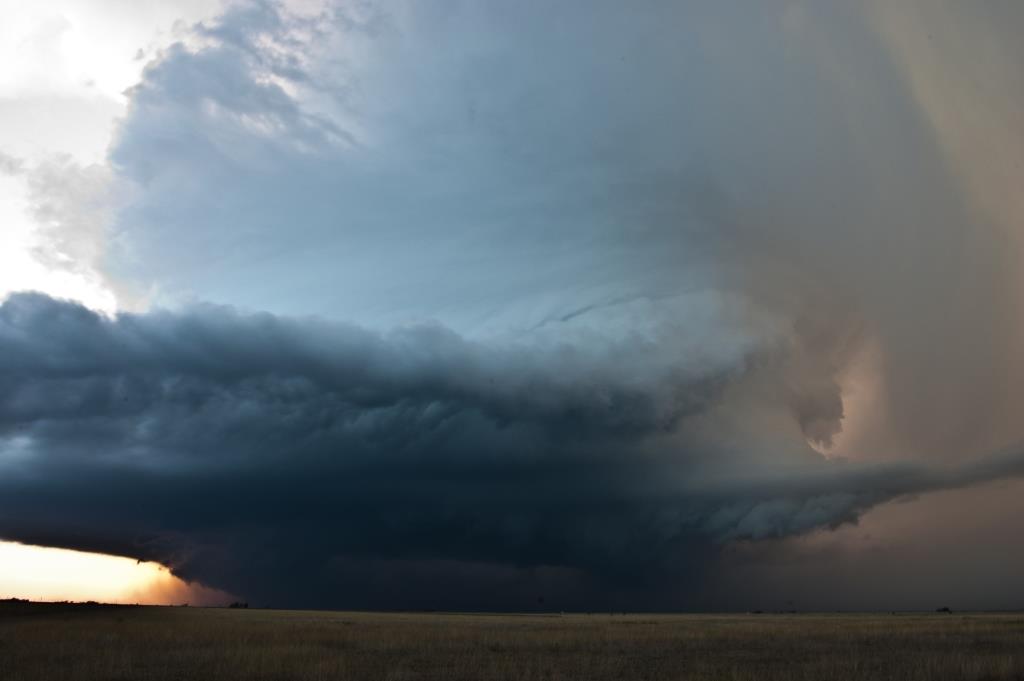
The photo above is heavily processed to bring out some detail and contrast, and I'm very happy with how it turned out. I especially like that I was able to capture a visible manifestation of streamwise vorticity being ingested by the storm, evinced by the curling cumulus texture running with the beaver tail coming in from the left. It was visibly rotating, although not exactly quickly.
This was my second chase in a row in which the most rewarding storm occurred after 00Z and after I figured the chase day was effectively done because the main daytime storms were petering out or evolving upscale. At least we were close enough to this one to get to view it, but this kind of crap is getting very frustrating.
Return to 2015 - chasing home page