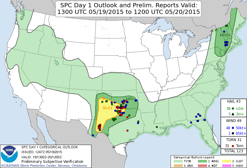
Summary: A lot of hazardous driving conditions caused by heavy rain. Lots of hydroplaning. Despite being in the wrong spot when the game started, I managed to see several tornadoes in southern Oklahoma, a third straight successful solo chase.
Chase partners: none
I left Norman around 1 PM with an initial target somewhere in the eastern TX panhandle or far western OK. I was going to sit around the OFB/WF and hope something popped and moved straight east. I punched through core #1 on I-44 just northeast of Chickasha. I only mention that because it was the first of about four in which I would punch through blinding rain and hydroplane so badly I could barely manage 40 mph. I never gave the arm of convection swinging northeast through central OK any credit because it was cloudy all morning in Norman and it was 65/61 when I left, so I figured those storms wouldn't have enough instability to work with to do anything. Sure enough, just after I pass Lawton, tail-end Charlie produces tornadoes just south of Norman. wtf...
As I continued west, I started to have doubts about my target area lighting up at all. By the time I got to Altus, I couldn't justify going any further west. Seeing new but disorganized convection now all around me, I semi-jokingly thought to msyelf, "as soon as I plow west too far to come back east, something between here and Wichita Falls is going to go severe/tornadic." Sure enough, after only 10-20 minutes sitting in Altus, two storms materialized out of the junk to my south and east. I decided they would be my play and turned around. Within 10 minutes of leaving Altus, the southeastern storm went tornado warned. I had to punch through its little brother to the northwest on my way between Snyder and Frederick (core #2). The CGs were a little more aggressive with that one than with core #1.
I popped out just north of Frederick and decided to go east rather than south, which would force me to punch into the back of the now tornadic storm passing over Grandfield at the time:
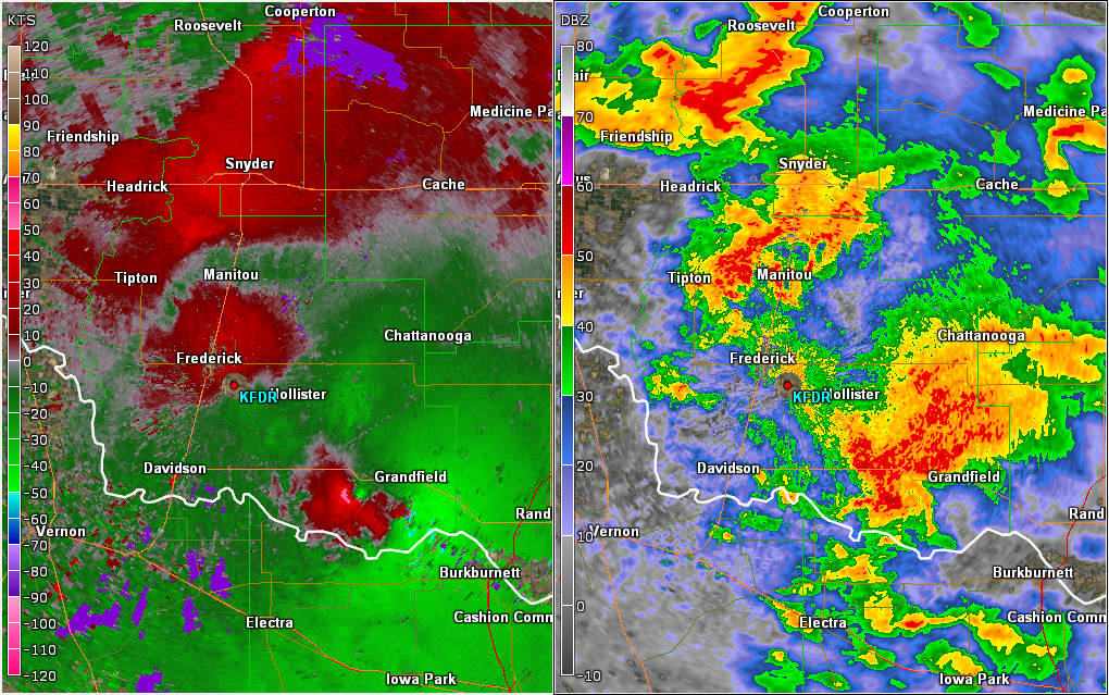
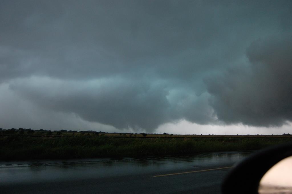
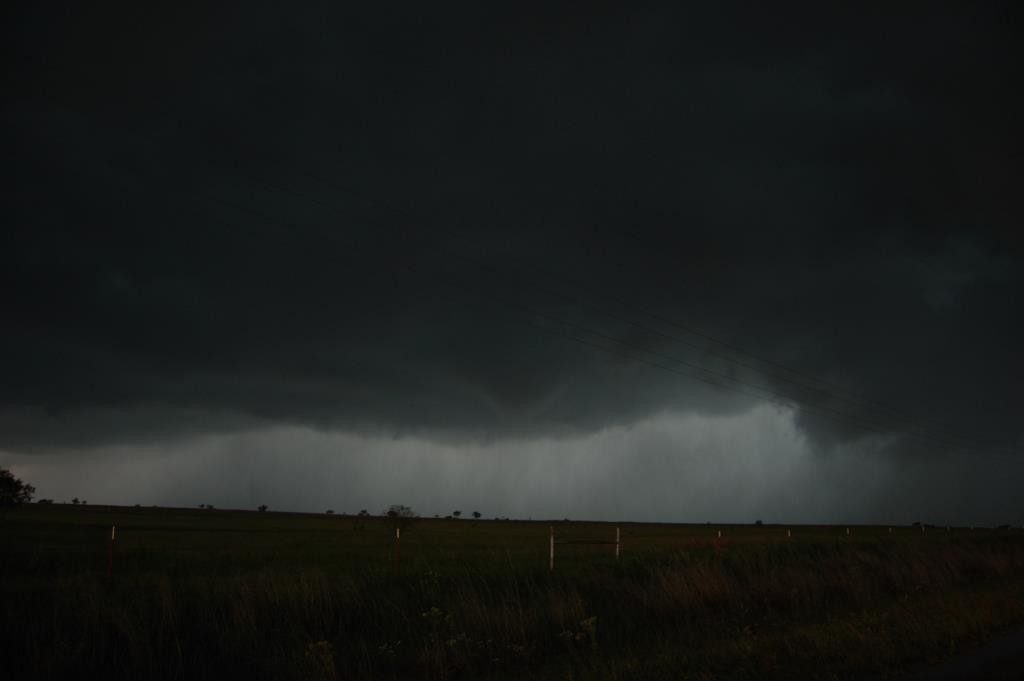
I was able to make pretty good time on OK-5 east of Frederick despite the quantity of water everywhere. The fields were lakes; the road had puddles all over. In some spots I was weary of water over the road, but I never came up on any. Catching up became difficult, though, once I was between OK-36 and U.S. 277 southeast of Chattanooga. It was pretty much a constant atomized rain with 30-40 mph easterlies along a section of road with a narrow shoulder and tons of water on it (core #3). Eventually the winds backed to the north and I began to worry that I was driving right into a circulation. Radar suggested there was a broad meso in the area, but nothing tornadic looked apparent.
I made the turn south on U.S. 277 and the CG barrage in core #3 began. I wish I had recorded more. CGs all around me, the blast of thunder arriving within a second or two on some strikes. Then the RFD winds tried to blow me off the road for a few miles before I finally popped out of the south end of the cell near Randlett. It didn't look like that storm was going to reorganize, so I gave up on it and decided to head east towards the yet undisturbed air where new development was occurring.
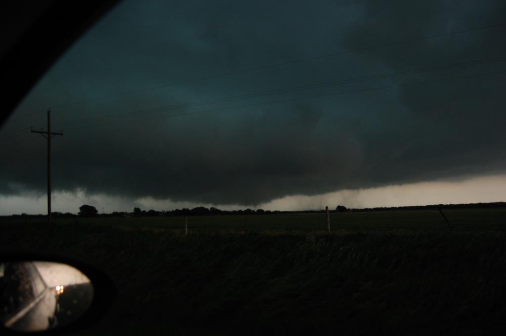
Before I even got to Waurika I was already disappointed, as the new storms looked to be immediately congealing. Although two separate cores had some rotation, it didn't look like either was intensifying. I decided to give these storms one last chance before I was ready to turn around and head home. I clipped the northern and eastern edges of core #4 on my way south towards the river. To my delight, one of the storms finally began to look like a supercell on radar as it approached the river. I stopped a few miles north of Terral, and the +CG barrage began. There were strikes occurring every few seconds in all 360 degrees around me; some were well removed from the updraft and precip core. I was too afraid to get out of my car to shoot better photos because of the proximity of many strikes.
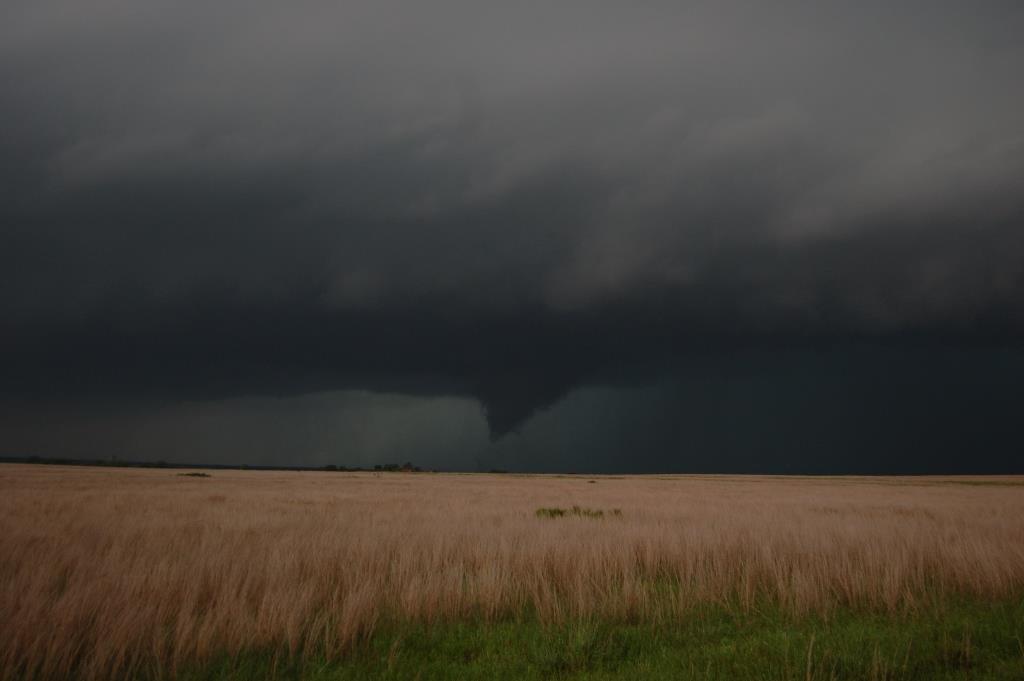
The storm appeared to form a wall cloud, but it never really appeared to organize that much. Seeing a tornadic storm 60 miles to my southwest in TX, I contemplated dropping the storm in favor of the one to the south. For whatever reason, I just never dropped it, and I'm glad I didn't. After the RFD/hook precip began to move in, I moved back north to try to get on its north side, because that strategy seems to work. I didn't see anything, so I turned back south. When I looked to my west, I saw a suspicious tapered lowering on the south side of the RFD precip(?). It had noticeable vertical motion low to the ground and was rotating a bit. It was coming right at me. So I zoomed down the road about a half-mile and watched it cross U.S. 81 north of me. I couldn't see any ground circulation, but I saw tightly wrapping rain curtains as it entered the field. Other chasers confirmed they saw whirls at the ground, so I guess it was a very weak tornado.
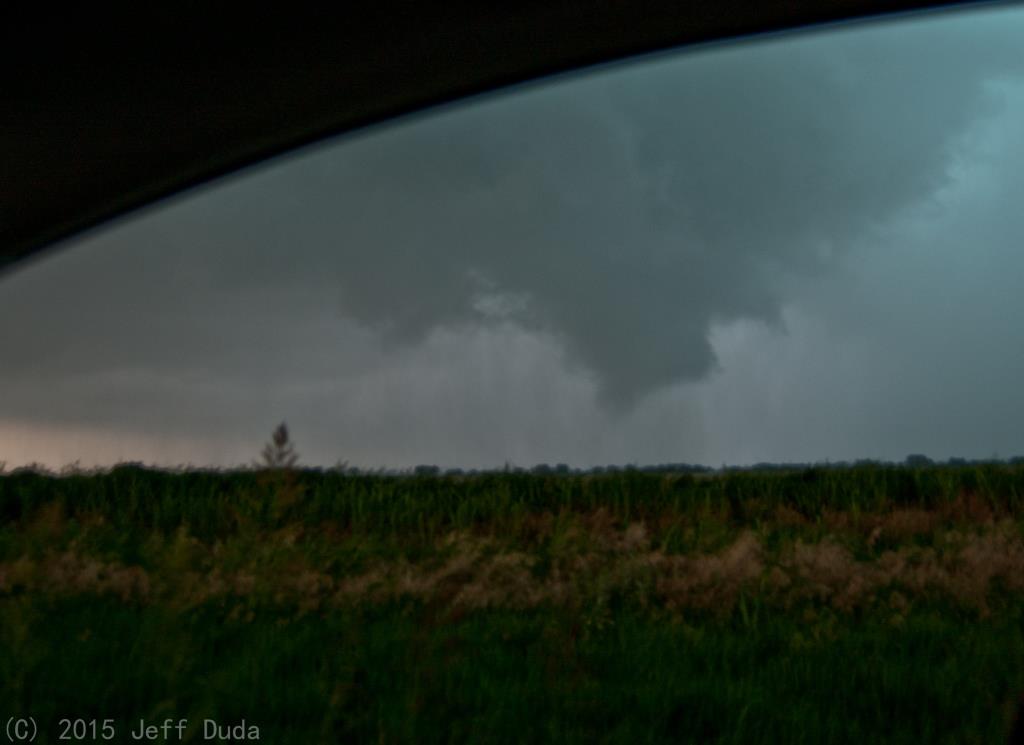
I turned to the northeast to watch it in the field because I still wasn't sure. That's when I noticed several cars coming back north. I turned to watch them and caught the base of the storm back to the northwest rotating rapidly. It was about to produce a tornado!
This tornado started off as a cone, then wedged out briefly before dissolving into a few suction vortices. Within a few minutes, it had become wrapped in rain. It wasn't weak, and it had a bit of a roar to it (definitely some Brown noise as opposed to pink or white noise).
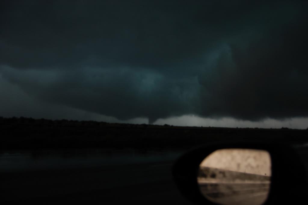
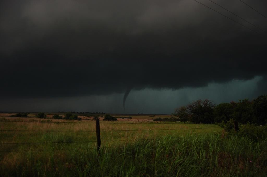
Looking back to the east, it appeared the storm had become cyclic, as there was a large ominous lowering back to the east where I had seen the first tornado move off. It was rotating and had fingers coming down, some looking like they were throwing up dust at the ground.
I was so glad I had passed by E2120 Rd previously, because I knew it to be paved, and it went east for a long time. Rather than driving north into blindness and potentially a strong tornado, I chose the former option. While the pavement became intermittent after a few miles, the road was in great shape, and I was able to fly east. I nearly killed a dog that ran off a driveway onto the road as I flew by. It was brownish red, the same color as the road, and it ran up to my car from the side. I came within 2 feet of ending its life. Needless to say, I'm very glad I didn't hit it. The storm looked like it was putting out funnels below the dark base left and right, but nothing ever came very far down until I turned back north on N2940 Rd. It was along this stretch that I witnessed at least two more tornadoes, one coming from an anticyclonically rotating wall cloud.
The storm was basically done producing tornadoes after that stretch. I did eventually follow it to Ringling where I decided to enjoy the dying core. As I began that venture, however, the storm began spitting out another insane barrage of CGs. Many hit close enough to shake the car. I managed to get one or two on video before my camera battery died. Very entertaining end to the chase.
I met up with Alec Scholten and Stephen Jones in Ardmore for a steak dinner. While there, a new storm prompted a Tornado Warning just to our west. It was moving so slowly, however, that we had more than enough time to eat a full meal and leave before it ever got to town.
Return to 2015 - chasing home page