Chase partners: Mason Rowell and Veronica Hall
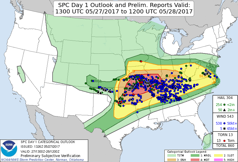
Summary: The big story on this day was the ridiculous instability. Dewpoints were forecast to remain in the upper 70s with surface temperatures above 90°F resulting in CAPE magnitudes exceeding 7000 to possibly 8000 J/kg! There was also enough shear for supercells, but forcing was on the weak side. Only a seasonal dryline and a remnant front (which was reinforced by outflow from storms to the north) would provide triggering for storms. And capping was a bit of a concern. The Moderate Risk was mainly for a forecast derecho across the mid-Mississippi valley to the north of Oklahoma, which arguably never fully materialized. Nonetheless, there ended up being a ton of severe weather, including in Oklahoma. I spent the day in the northeast corner of the state, but only caught one supercell that spent its entire life behind an outflow boundary. Nearly got hailed on big time, too.
Veronica and I left Moore around 4 PM. On the way towards Tulsa we drove under a developing band of mid-level convection that was spitting out CGs as well as moderate rain. I was concerned that this area may intensify and end up overturning the atmosphere, but thankfully it harmfully moved on. We picked up Mason at the Wal-Mart near the Hard Rock Casino on the far northeast side of town and continued northeastward. Storms went up along the outflow boundary in far northeast Oklahoma as we did this. These storms exploded in the 5000+ J/kg CAPE atmosphere. They had some of the most crisp backsheared anvils I had seen in years. It was very impressive. The storms rotated right away. The problem was they developed in a "zipper" fashion down the boundary, so each updraft was quickly dumped on by the next precipitation core/downdraft immediately upstream of it. Despite couplets and tornado warnings, no tornadoes occurred.
We pulled off the turnpike at Vinita and headed east on U.S. 60 towards Afton. We took the unpaved grid on the way. The storm initially had a nice meaty lowering, but it struggled to consolidate into any concentrated rotation. Moreover, storms barfed outflow and the gust front started to get pretty far away from the precipitation, so it became pretty clear these storms no longer had tornadic potential. So we began focusing our attention elsewhere. We noted a new and discrete storm had gone up back to the west. The only problem was it was clearly behind the outflow boundary that triggered the initial storms. However, we had no other choice – it was chase this storm or go home. So we bailed west from Vinita and headed towards Bartlesville.
We barely beat the forward flank of this sculpted supercell to Nowata and turned south on U.S. 169.

We ultimately pulled off 169 at E028 Rd. and sat under the base of the storm. It was very tranquil given we were inside the neck/hook echo region of a supercell. It was pretty clear to us this storm would not produce a tornado, but if it was going to, it would have been within a few miles to our southwest. The base of the storm remained flat and featureless and we could discern a horseshoe shape demarking the RFD (visible in the image below). Surface winds remained rather light, though. Eventually the sun began shining on us by cutting through the vault region to our northwest, increasing the tranquility factor.

After 10 or so minutes we decided to get ready to leave to stay with the storm. I faintly recall hearing a medium-timbre roar to our north. I knew what it was, but I didn't think much about it – a hail roar. As we got back to 169 we stopped for a few seconds for Veronica to snap a few pictures of horses running in a field next to the road. As she snapped a picture I thought I saw a white object fall near one of the horses. The horses then started to get a little excited and took off, ending Veronica's photo op. Then another white object. Oh crap!
There was a line of chasers going south on 169, also escaping the hail. So we had to wait for a little bit before getting south, taking hits from a few large stones in the process. It was alarming, and I remember shouting, "someone film this!" I figure if my car is gonna get smashed up twice in one year I'm at least going to make sure it gets fully documented the second time. Well, we got out of the hail pretty quickly before it did any visible damage and ended up not having much to actually film. Also it appeared to be soft, breaking quite easily on impact. We didn't stick around to examine any stones closely, but my guess is the biggest ones were in the golfball to tennis ball size range.
We turned east again a few miles south to go east on the only thru road for quite a few miles. It crossed Oologah Lake. On the way to the lake we passed what looked like an old space capsule just a few feet off the road, with soil churned up around it. It wasn't reasonable to think it just fell there, but it was very strange to see nonetheless. After we made it over the lake, chaser traffic slowed down and we ended up finding ourselves back in the hail core as it sank southeast into us. There were several anxious minutes working our way east towards Chelsea. We finally shot south and out of the crowd at S4240 Rd, and that was it for the hail and our chase. Thankfully the car did not appear to take any additional damage (not that I would have been able to tell anyway).
We dropped off Mason and he suggested a nice pizza restaurant in Broken Arrow. While eating there a new storm developed halfway between Tulsa and Oklahoma City near I-44 and quickly organized and went tornadic. But once it produced the one tornado it also seemed to become HP and lost its organization while storms in southern Oklahoma also really took off. The drive home on I-44 was very pretty as we passed by these storms to the north. We stayed out of the rain the whole time, but the lightning show was fantastic.
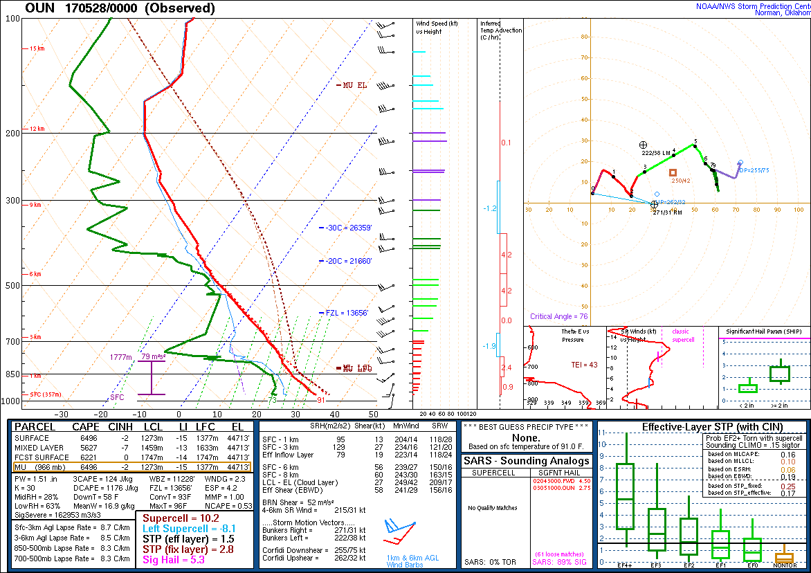
The 00Z Norman sounding didn't capture the instability maximum, but still...5500 J/kg of MLCAPE with 56 kts of 0-6 km shear (yes, the kink hurt SRH a bit):
Also, a field project was actively conducting soundings this day in Oklahoma and measured some environments that likely had 8000 CAPE (the soundings were cut off before the full data set was obtained). Also, one sounding launched into the updraft of one of the southern Oklahoma storms sampled vertical velocities ranging from 26-42 m/s (the latter being equivalent to 102 mph). As far as I know that's the largest measured (or reliably estimated in-situ) updraft velocity ever. Very cool.
Return to 2017 - chasing home page