
|
|
|
|
|
|
|
|
|
|
|
|
|
|
|
|||||||
|
|
|
|
|
|
|
|
|
||
PIRCS
A question that arises is "how good are regional models at reproducing climate features of
the past?" The Project to Intercompare Regional Climate Simulations
(PIRCS)
consists of a series of experiments where modeling groups around the world are performing exactly
the same simulations for intercomparison to evaluate capabilities of models to simulate details
of regional climate. The RCM vs. GCM domain (Figure 6)
shows the relationship between regional climate model
grid points (blue over water and green over land) and global climate model
grid points (red). In the PIRCS experiments, the global model gives
information at 6-hour intervals only along the outside frame. The regional
model then uses this information to calculate the pressure, wind,
temperature, humidity, precipitation, etc at each RCM grid point on the
surface and about 16 levels in the vertical at 3-minute intervals until
it gets more information from the global model 6 hours later.
The first experiment conducted under this project was a simulation of a short period (60 days) during the 1988 drought, Figure 7, in the central US (15 May - 15 July 1988). This period of minimal precipitation was chosen so that model response to radiative forcing could be examined with minimal complication by clouds and moist soil. Eight models participated in this intercomparison.
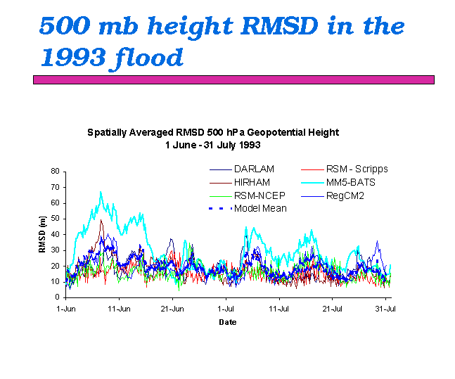
The root-mean-square difference from observations of the 500 mb flow, Figure 8, for each model gives an overview of how well each model simulates the large-scale flow. As we saw with results of global models, there are some models that are superior for certain periods but all cluster around a departure (error) of about 20-30 mb. Although the spatial patterns (figure not shown) of large-scale flow differ for different models, results generally show largest errors to be toward the middle of the domain. Evidently, models create larger errors at locations near the center of the domain where the model has maximum freedom and smallest errors near the constraining boundaries where conditions are specified.
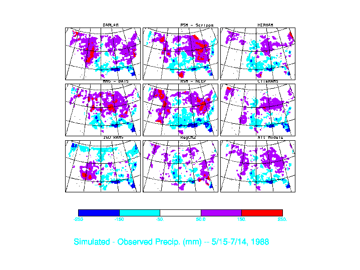
Figure 9 shows how each model simulates total precipitation by giving the error (difference between simulated and observed) over the 60-day period. The composite of all 8 models given in lower right shows that the aggregate of all model results has relatively low error. Most models have too much precipitation in the northern part of the domain and not enough in the southern US.
The day-by-day precipitation amounts for the upper Mississippi River Basin on are shown in Figure 10. The actual observed amount is shown by the heavy black line. Note that for days 136-164 and 178-196 precipitation occurred in discrete events usually separated by dry periods. By contrast, the period 165-177 was a period of day-after-day weak precipitation events. Generally the models capture the occurrence of events during periods when rain comes in discrete episodes. Models generally produce too much rain in the period 165-177. However the overall ability of the models to produce an aggregate of total precipitation is quite good. A plot of accumulating precipitation totals shows most models to be producing too much rain during the period.
The next plot shows model values of incident solar radiation at a point in Kansas where measurements were being taken during this period in summer 1988. With exception of a couple of models, most simulations give the appropriate amount of shortwave energy.
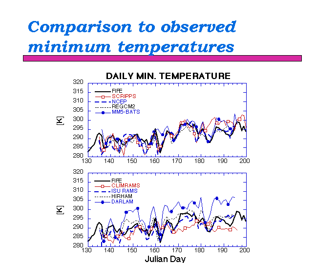
Plots of daily maximum temperature, Figure 11, and daily minimum temperature, Figure 12, reveal differences in model capabilities in representing day-to-day changes. Some models evidently are quite good at capturing occurrences of warm and cool days. Comparing this graph with the graph for daily minimum temperature shows that minimum temperature is simulated somewhat better than daily maximum.
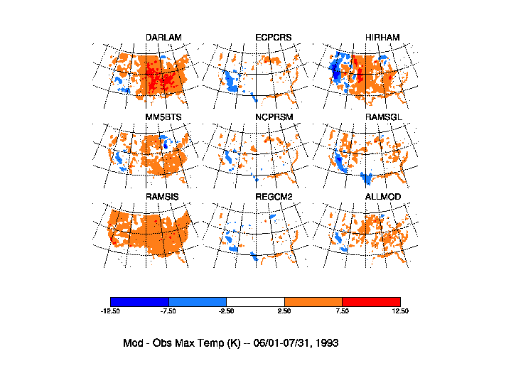
Previous plots gave temperatures for a particular point whereas the next two plots give model error for daily maximum and minimum temperature at all locations across the US for the month of June 1988. For maximum temperature (Figure 13) it is interesting to see that, while some models (e.g., DARLAM) seem uniformly too warm and other models (e.g., ISU Rams) are too cool, the aggregate of all 8 models (ALLMOD) gives results that are quite close to observations. For daily minimum temperature (Figure 14), by contrast, some individual models give results closer to observations than the aggregate of all models.
PREVIOUS: Regional Climate Modeling
NEXT: Extreme Weather Events and Regional Models