
|
|
|
|
|
|
|
|
|
|
|
|
|
|
|
|||||||
|
|
|
|
|
|
|
|
|
||
Geostationary Operational Environmental Satellites (GOES)
Figure 3
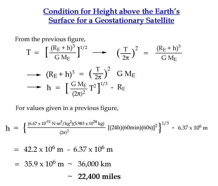
For the special case of when the period of rotation exactly matches the rotational period of the earth (24 hours) and if the satellite is placed in orbit over the equator, then it will appear (when viewed from the earth) to be stationary over a particular point on the earth. This unique condition requires that the height of the satellite above the earth should be (Figure 4)
h = [(G*ME)/(T/2¶)2]1/3 - RE
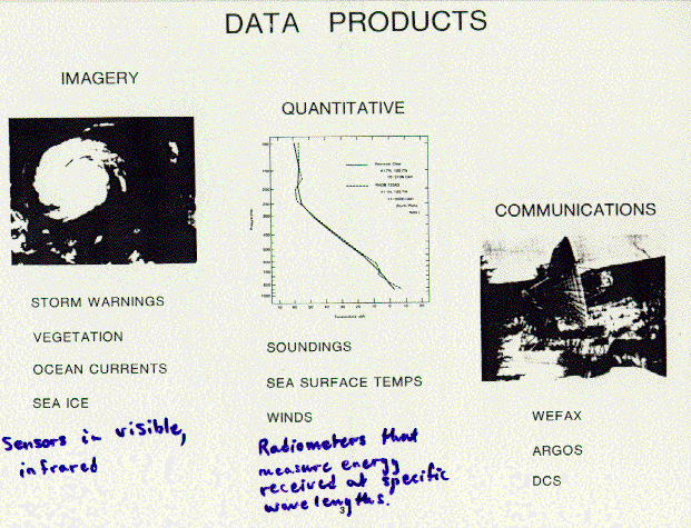
The position for such a satellite is about 36,000 km (22,300 miles) above a fixed point on the earth's surface known as the sub-satellite point (Figure 5). These satellites have the advantage that tracking devices are not required to receive their signals, so fixed dishes, similar to a typical TV dish, are suitable for transmitting and receiving signals from these satellites. Their large distance from the earth provide an advantageous perspective for geostationary satellites to view the entire face of the earth simultaneously, which is particularly useful for snapshots of large-scale cloud patterns. GOES satellites are placed in stationary earth orbits at locations designed to give maximum coverage for the particular application. For example, the US National Oceanic and Atmospheric Administration has 2 GOES satellites (Figure 6 ), one over the equator at 75 oW and the other at 135 oW. These two satellites give coverage of +/- 50o latitude and longitude from the sub-satellite point, which allows continuous coverage of the continental US and adjacent oceans. In periods when one satellite fails, the other can be moved to 1000 W, which gives suitable coverage over the continental US, but fails to give data from the northeast Pacific Ocean, from which region storms frequently enter the US. Data received from GOES satellites may be of several types (Figure 7). Image (picture) data in both visible (reflected solar light) and infrared (emitted from the earth, atmosphere, water vapor, and clouds) are recorded by the Visible and Infrared Spin Scan Radiometer (VISSR). The VISSR Atmospheric Sounder (VAS) measures the vertical structure of temperature and water vapor in the atmosphere for initializing weather forecast models. The GOES also has a Space Environment Monitor (SEM) for monitoring earth magnetic fields, solar storms, and sunspots (Figure 8). Some weather-related products derived from GOES data include:
The NOAA website provides updated information on the GOES satellites.
NEXT: Polar-Orbiting Satellites