This day would be my first successfully chased April tornadoes (not counting the Iowa City one in 2006 because I didn't chase it) and the first year in which my first chase yielded a tornado. Not only that, but it was a multi-tornado day, and it turned into a successful night chase after we sort of failed during the day. Inflow was also the story of the day, as I experienced inflow winds among the strongest I ever have. It was quite an experience!
I saw this storm system coming a week in advance. The big question of the day was whether or not the cap would break. After last year's cap bust in Missouri on April 5th, I was fully prepared to accept another cap bust. The upper level forcing in this case was stronger, but it was still well to the west. Fortunately, the triple point saved the day by causing initiation, and the warm front gave us the show.
I left Ames with Logan and Adam around 11 AM, then picked up Ryan in Polk City and headed west on I-80. We stopped in Council Bluffs to eat at Quaker Stake and Lube - Best Wings USA. I was first introduced to this place after the June 6th, 2009 cap bust in western IA. It's a nice wings place, but they also have steaks, salads, sandwhiches, burgers...quite an impressive selection. Anyway, after eating, we went to Fairmount Park in town. It sits on the edge of the Loess hills looking west, so we had a great view of downtown Omaha and any weather activity that would be coming in from the southwest. After seeing a CU field develop about 50 miles to our WNW in eastern NE shortly after 4 PM, we knew initiation was not far away. We zipped across the river and headed towards Fremont, NE.
We filled up for gas in Fremont. Surface winds had been accelerating notably during the afternoon since we first arrived in Council Bluffs. In Fremont, the winds were pretty stiff out of the ESE at probably 20 kts. It was obvious that we were near the warm front. We drove north on U.S. 77 following a persistent tower that slowly strengthened as it moved NNE. We caught up to it around the time we got to state highway 51, where we turned east in preparation to cross the river back into Iowa. I was worried we might get screwed by a river crossing this day, but thankfully, the storm waited until after it crossed into IA to go crazy. The storm appeared to slow down and make a right turn as it got north of 51.
We stopped just west of Onawa, IA along state highway 175 just off of I-29. This is where the storm really got going. It had developed a large rain-free base, but then suddenly a textbook RFD cut appeared.
I didn't get too excited at this sight because there was hardly even a hint of a wall cloud forming, or much rotation in the base near the cut. Inflow winds were picking up and the sandblasting was beginning. The storm apparently spit out a cluster of gustnadoes and tornadoes during the next several minutes. I never saw a funnel or much rotation, but I wasn't in a great position either. Others got much better video and it is obvious that there was at least one tornado in here and several gustnadoes.
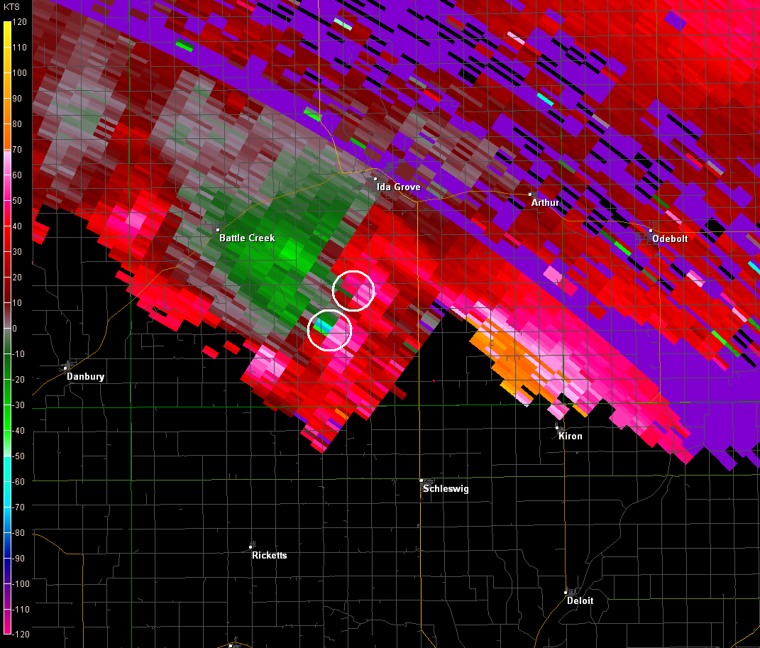
We cut through the Loess hills via some dusty, twisting roads and emerged back on 175 at Castana. The storm appeared visually unorganized during this time, as little in the way of traditional supercell structure was visible. However, as we neared Mapelton, the radar presentation of the storm became more impressive and I was able to see wrapping rain curtains to our WSW as we neared town. We encountered nickel to quarter sized hail as we went through Mapelton, which caused Logan to freak and make us get way east of town (we were chasing in his new Civic, and he refused to get it into hail). I was thinking of having us stop a mile or two east of town along county highway E16, but we kept going east for 10 miles east of town, still getting occasional nickel to quarter sized stones the whole way (we were driving along the reflectivity gradient of the FFD). It was during this time that the Mapelton EF3 tornado touched down and moved into town. We didn't see the tornado at all, but when we pulled off the highway a few miles south into a field at the top of the hill just ENE of Ricketts, we proceeded to get blasted by intense inflow winds. The thought occurred to me to grab my sonic anemometer. I measured sustained winds well into the middle to upper 40s kts with gusts over 50 kts. I measured a maximum gust of 53 kts.
We moved northeast, but daylight was fading fast. The Mapelton tornado occurred just before sunset, so even that wasn't well lit. We chased the storm as far as a few miles north of Schleswig before I figured we messed up and would end up going home without a tornado for the day. We stopped along county highway D54 and watched a big, wet RFD cut in this HP supercell disappear in the darkness. I got some extended exposures from my D40 by holding my hand against the roof of Logan's car. The pictures came out amazingly well given the inflow we were still witnessing. I didn't even realize it at the time, but I caught something very suspicious in one of the images:

After this stop I figured the chase was over, as it was pretty much fully dark. We started driving east looking for a way home when we spotted Skip Talbot just off the road north of Kiron. We decided to stop and say, "hi." I don't think Skip saw it was me at first, because he began to introduce himself when I told him it was me (it was dark and windy - I don't blame him for not noticing). Of course, he and his chase partners Mike Boik and Jennifer Brindley saw the Mapelton tornado. I wasn't happy about that whole thing. We talked for a short while and watched the lightning-illuminated supercell continue to lumber to the northeast out in the field. After watching it for a few minutes, a very pronounced wall cloud emerged from the base to our north. A few moments later, a narrow funnel poked out of it. A few moments later, a tornado was on the ground! Little did we know, but our night had only begun.
The chase was back on! We rounded some turns and headed north up state highway 39 towards Odebolt, then east on 175 again, then north on U.S. 71. We stopped again somewhere in here and saw more tornadoes likely, although I don't have any solid pictures of them. I'm not even totally sure I saw one, but I definitely saw multiple lowerings and wall clouds. The inflow winds and rain-softened soil was causing me all sorts of hell taking pictures. I couldn't get my tripod to stabilize.
We continued into Sac City, then north out of town on county road M54. A few miles north of town we drove into some RFD, so we turned around and went back out of Sac City eastward. I was getting at best, intermittent radar updates during this time, so I did not know exactly where the threats were. I also had no idea the storm was wobbling on its track so badly so that it was hard to keep a line with. I knew it was cycling repeatedly, though. We stopped again near Lytton, where I snapped a series of wonderful structure shots. Being a typical HP supercell, this thing was well lit by lightning.
We ended up passing by Fonda, which was without power. Pretty sure we saw two funnels touch down to our northeast on the way to Fonda. We stopped for a long time at the intersection of state highway 4 and 590th St. west of Palmer. I took some more pictures. More great structure, plus more suspicious lowerings well off into the distance.
We let the initial storm move off to the northeast by Pocahontas. We saw a second supercell moving almost straight east behind it. The second one looked a little better by this point and was moving straight at us. Thus we drove a few miles west down 590th St. to watch the hook come in. Saw some features under the area of interest on the second storm, but nothing significantly indicative of a funnel cloud or tornado. Lighting was a little less frequent on this cell so it was a little harder to see. I don't think any tornadoes occurred from this second storm here. Managed to get a great shot of a saucer shaped mesocyclone, though.
Called a night finally at about 10:45 PM, turned around and headed home.
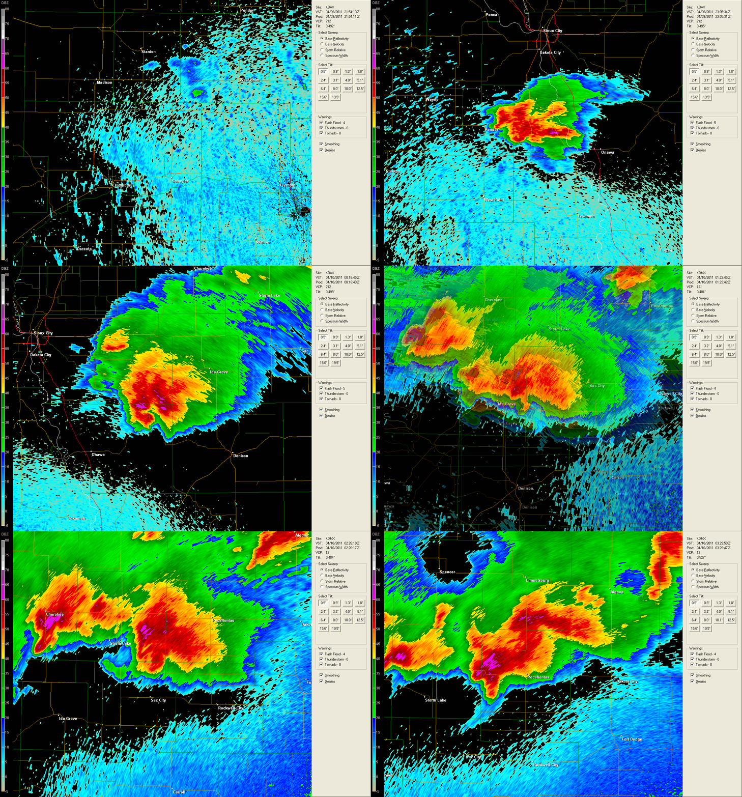
I made a reflectivity loop from a combination of KOAX and KDMX which is centered on the initial supercell from birth to around the time it was eaten by the supercell coming in from the west. It's no wonder to me how it was so difficult to stay in the right spot with this storm: it lumbered and wobbled around as it moved east and northeast. It was also highly cyclic, sometimes appearing to have three wall clouds existing simultaneously. See the loop below: (26.0 MB)

The velocity images from KDMX are pretty dirty and aliased, so it's hard to see exactly what the storm looked like at some times, but there were a lot of hints of multiple circulations on the storm.
Return to 2011 - chasing home page