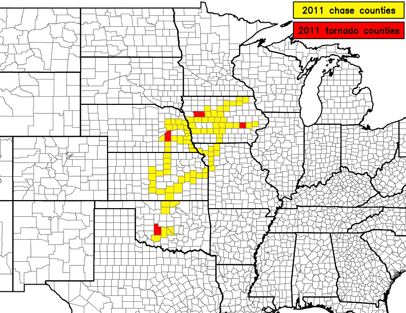
2011 Chase Season
My 2011 goal was to get closer to any tornadoes I should happen to see. I achieved that goal!
Scored a multiple tornado day on my first chase of the year, a first! Experienced my worst two chase busts ever, both in KS or OK, in May. My first two successful chases were in Iowa. June was rather quiet with only three chases for the month. It was looking to be my worst season since I started chasing in 2008 when a seasonably strong trough moved in and gave me the best day of the year, and arguably one of my three best chases of my short career on June 20th. Great success in Nebraska to close out the year!
April 9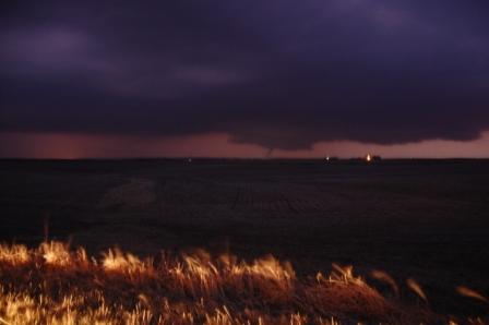 |
May 22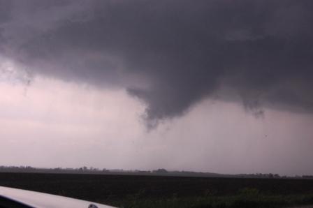 |
June 20 #2 chase 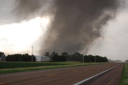 |
Chased the advancing dryline/cold front in northeast Iowa. Left Ames around 1 PM and managed to be very near the first storm of the day at initiation. However, as was progged, storm speeds were ridiculous, and we fell behind it quickly. Numerous other cells began to go up to the southwest of the first one, thus putting us in position to intercept numerous cores coming up the line at us. Unfortunately, low level shear appeared to be lacking, and instability must not have been great. None of the cells went severe unless they were within about 5 miles of the Minnesota border. Managed to intercept one cell in Ridgeway, IA that produced quite a hefty downburst with blinding rain, a nice gust of wind (yeah, just one), and some beebee-sized hail. I was happy just to get the hail. I was also impressed that the terrain held up all the way into western Winneshiek County, IA (i.e., near Ridgeway where we stopped and turned back).
My worst chasing bust ever. Seeing a calm pattern taking over in the next several days, I decided to go farther out from Ames than ever before. Left Ames at 5:00 AM for a Pratt, KS target. Made it there at about 3:00 PM and quickly realized the day would bust, as an unpredicted overnight MCS and repeated redevelopment in TX and OK pretty much wiped out the thermodynamic environment to the north. Turned for home when the cirrus shield spread in from TX and OK, thus capping the environment with little instability. I also missed two tornadic storms in IA that went berzerk for some reason in spite of weak 500 mb flow. This chase was a 1060-mile, 21-hour humiliation.
Images (if you're friends with me on facebook...sorry otherwise, but you're not missing anything)
The May 11th epic chase bust was not to be outdone! Just two weeks later, a powerful shortwave and high risk day persuaded me to make the trip back to south-central KS. Only this time, we were pulled into north-central OK when storms fired early and southwest of our target area. We made a mad dash for one particular tornadic supercell, but it crapped out as we approached it. Then, of course, the outflow boundary from the morning MCS to the north decided to result in numerous tornadic supercells to our north in western/central Kansas while we were messing around with the crap in the middle. Thus, again, we missed absolutely everything. I haven't a single picture or video from this 1060-mile top end bust. As a final insult from mother nature, on the drive home, the storms that went by decided to persist and develop into an MCS as it sped northeast at almost the same speed we did. I had to drive in moderate to extremely heavy rainfall for three straight hours from somewhere near El Dorado on the Kansas Turnpike to north of the Kansas City metro area, and then again once we got back into Iowa. For as much money as I've paid to drive on the Kansas Turnpike, the road sure does get slippery when it gets dumped on. Pretty poor drainage if you ask me.
A pathetic cap bust in the southeast NE, southwest IA, northeast KS, northwest MO region. The same setup occurred at least three times within a week of this day: a surface warm front crept slowly northeastward during the morning and early afternoon, then suddenly stopped and retrograded back to the southwest during the late afternoon. Add to that a stout EML and thus strong cap moving in from the southwest and the fact that stratus blanketed every square inch north of the warm front, and you get a very narrow baroclinic zone at the surface with a cap above it. Thus you have great shear but no instability north of the warm front and great instability with sufficient shear but towering LCL heights and a cap south of the warm front. That means no tornadoes no matter how high the significant tornado parameter is. Plus, we had to drive through Missery with its horrible county highways on the way back to I-35. Fail.
As a strong late-June trough set up across the Rockies, this day offered some "day before the day" action. There was a warm front setting up across northern KS into northern MO with huge CAPE and sufficient shear. The biggest problem again was the cap, which held strong through northeastern KS and northern MO, save for one brief tornadic supercell south of I-70 near Salina before dark. Since Logan and I decided not to chase south of I-70 anymore for the remainder of the year, we had no play (plus the storm developed pretty late). We made it as far south as Cameron, MO before giving up and turning around. Then there was the amazing string-of-pearls supercell train that developed at around 9-10 PM across southeastern NE and southwestern IA. Only one of them produced a tornado, but the storms looked identical on radar for a solid hour or more. Quite a sight. But nothing like what the next day would bring.
I told myself that June 20th was my last chase of the season. I wasn't paying a ton of attention to this day since the SPC convective outlooks weren't showing much of interest that would be reasonably close. I was awakened by a text message from Logan at 9 AM that says, "wtf?! 15% hatched tor!" I had seen the previous day 2 outlook from the day before, but the 30% hatched probability for severe weather disappeared in the afternoon update as the forecast became less certain. Even the 06Z day 1 update did not have much more. Then, all of a sudden, the 12Z day 1 update flew in with this 15% hatched tornado probability and indicating the wording of strong tornadoes. So I got up, still kind of tired, and immediately checked all of the available data. The data told me that it looked good if 1) the warm front made it as far north as the models were saying it would, and 2) the cap stayed south. However, a stratus deck made its presence known early in the morning on visible satellite over the exact region depicted in the 15%/hatched tornado contour. After a few hours of watching the stratus mostly stay (but start to erode towards noontime) and the warm front essentially make no progress north, as well as seeing some pretty warm 700 mb temperaures move in (see 12Z observed, 15Z analyzed, 18Z analyzed, and 20Z analyzed 700 mb temperatures), I was somehow compelled to get west because the HRRR continually spat out a large cluster of supercells across western IA and eastern NE. However, shortly after leaving Ames with Logan, the stratus deck, which had been eroding rapidly from east (in Iowa) to west (into eastern Nebraska) and from south (in Kansas) to north (into Nebraska) began filling in again. Also, a plume of thundershowers began developing out of a stationary origin somewhere west of Omaha and sent a west-east band of precip across most of eastern NE and into western IA. It was persisting and moving due east. The HRRR was not capturing these features. Thus, we decided that it was going to be a cap bust and turned around.
On our way home from Adair on I-80 we spotted a storm blowing up in southwest IA. We didn't see evidence that it would become a tornadic supercell (possibly an elevated supercell), but we decided to intercept it anyway for the chance at some large hail. We spent a good 30-45 minutes under the maxed-out VIL core between Greenfield and Creston and sampled plenty of hail, but pretty much all non-severe. There may have been one or two 1" sized stones, but most of it was nickel and below. At times it looked like maybe the storm was trying to turn into a supercell, but it suddenly weakened as it began to go outflow dominant. It would end up being part of a complex that would form into an MCS across southeastern IA towards the early evening hours. We left it and drove home. I still spent 6 hours, 270 miles, and $20 of gas on the road for a chase, but I consider this one a moral victory since we had the knowledge to call it off pretty early and did not cap bust. We actually had some fun in the hail core, and it was more than we would've otherwise seen.
SPC finally removed the 15% tornado probability in the 20Z outlook but left the hatched in there. Here's how that risk verified: http://www.spc.noaa.gov/products/outlook/archive/2011/day1otlk_v_20110626_1300.gif. There was a tornado reported from a brief supercell in far northwestern MO, although it hasn't been verified. There was also a confirmed tornado in western IA, but at 8:40 PM and part of the leading edge of the raging MCS that swept across the state that evening.
Ahh, the benefits of moving to Oklahoma. Of course I had to endure the second half of the hottest summer ever and the peak of one of the driest years ever (not to mention three of the strongest earthquakes ever to occur in Oklahoma), but quite an opportunity arose when the models forecast the chance of significant severe weather this day. The setup didn't look that great in the models leading up to this (mainly, instability was lacking...generally < 2000 J/kg was forecast). However, the models underdid the surface temperatures because the forecast precip that was supposed to block out the insolation during the morning did not materialize. Hence, CAPE actually exceeded 3000 J/kg in the area of interest. Since my car's brakes had recently gone down the tubes, I was temporarily without an automobile. While I recognized the opportunity for the day and wanted to go, I could not find anyone who would let me chase with them. I thought I would have a miserable day watching it all unfold from my NWC office, but at last I was able to get out with Jeff Snyder and Howie Bluestein! (yes, I was somewhat star-struck at being able to chase with him).
We left Norman at 3:30 and headed down I-44 to try to intercept the main supercell that had already produced several tornadoes. We listened to more reports come in through the spotter radio networks as we went. This was a limited technology chase, as all we had was our cell phones. Amazing that we could manage a chase like this with just cell phones, but my phone alone has mobile data and a mapping software with GPS, so that was really helpful. We managed to get on the storm just as it was going through its last cycle near Fort Cobb. We saw the tornado as it went through almost the entire spectrum of shapes, from bowl to wedge to multiple-vortex to cone to stovepipe. At the closest point we were paralleling it on OK 146 north of Fort Cobb as it moved mostly north. The storm had been moving northeast, but turned back to the NNE during the end of its life as it began to weaken. Once the meso occluded and the tornado pulled back into the storm and died, the storm fell apart and we headed back to Norman. Got back by 7 PM! Of course it had pretty much been dark since when we broke off the chase, but for leaving at 3:30 in November and getting to see a tornado, I'd call the chase successful. Unfortunately, since I didn't have my D40 with me, I could only get shots from my cell phone, and those didn't turn out very well. Oh well.
Images:Return to storm chasing home page.