Chase partner: Tim Supinie
Summary: This chase easily goes down as my worst of 2015, and likely one of my top 3 worst lifetime (only 11 May and 24 May 2011 come to mind as being worse). The chase can be summarized using the following image, which should serve as a reminder to everyone that the MOST DANGEROUS aspect of chasing is DRIVING, not just during the chase, but to and from the target area, when it's likely to be dark, you to be tired, and you to drop your guard.
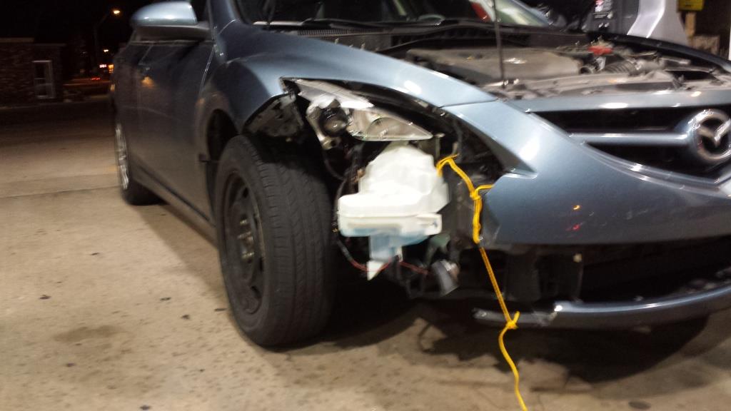
That's what the front right corner of my car looked like after hitting a fawn or small doe at 60+ mph.
Meteorologically, we saw zero tornadoes, although we saw several likely funnel clouds and some rotating wall clouds, as well as a very suspicious feature well off in the distance after dark. This was despite being on the two storms of the day in the TX panhandle well before sunset. Then we hit the deer.
We left Norman at around 11 AM. We initially staged a mile north of I-40 on F.M. 294, just a few miles northwest of Groom. Oh, if only we had just stayed there...

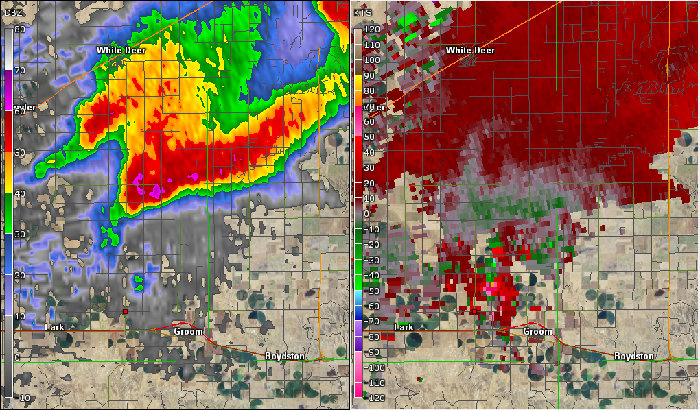
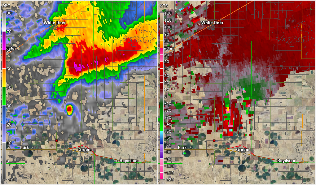
| 0.5 ° reflectivity and velocity at 0036, 0041, and 0044 UTC from KAMA with the red mark showing our initial staging point northwest of Groom. Notice the blob of very high reflectivity develop during this period? We would've likely had a tornado pass almost on top of us had we had the patience to it there for three hours. See the blurb below from NWS Amarillo's damage survey on it |
A tornado we would've almost been hit by:
TORNADO #7: GROOM STORM...
RATING: EF-2
ESTIMATED PEAK WIND: 115 MPH
PATH LENGTH /STATUTE/: 10 MILES
PATH WIDTH /MAXIMUM/: 175 YARDS
FATALITIES: 0 INJURIES: 0
START DATE: 11/16/2015
START TIME: 6:42 PM CST
START LOCATION: 5 MILES NORTHWEST OF GROOM
START LAT/LON: 35.253 / -101.158
END DATE: 11/16/2015
END TIME: 6:55 PM CST
END LOCATION: 13 MILES NORTH OF GROOM
END LAT/LON: 35.382 / -101.080
THIS WAS THE FIRST OF TWO TORNADOES PRODUCED BY THIS SUPERCELL. THE
MOST SIGNIFICANT DAMAGE WAS TO A STURDY STEEL CONSTRUCTED
OUTBUILDING WHICH WAS COMPLETELY DESTROYED. DAMAGE TO A NEARBY HOME
INCLUDED BROKEN WINDOWS...REMOVAL OF ROOF DECKING MATERIAL AND
UPLIFTING OF THE ROOF. 2 BY 4 PIECES OF WOOD WERE EMBEDDED IN THE
ROOF OF THE HOUSE. A LARGE FLAT BED TRUCK WAS MOVED 50 YARDS.
After watching several towers start to go up and get sheared apart to our immediate SSW, we decided to move south a little to get a better vantage point of showers/weak convection well to our southwest. We moved to a spot near the intersection of FM294 and FM1151 about 10 miles east of Claude, where we sat for almost an hour before we got impatient with the one good looking cell that was approaching Tulia at the time. We booked it west and south through the canyon on TX-207, turning around a few miles after popping back out of the canyon. What initially appeared to be a ragged disorganized base a few miles to our west evolved into a weakly rotating, but high based wall cloud that we intercepted near Wayside. It had a moderately strong RFD push. We went back into the canyon, fighting with data availability, when we saw it get tornado warned. It was still rather high based at this time and there wasn't much low-level rotation.
Eventually we cut east and north using FM 2272 through another canyon south of Goodnight. On our way east we saw a pretty tightly rotating wall cloud. It was pretty narrow, and it appared to spit out one or two funnels, but we never saw anything come close to the ground. Then we started to lose it in the fading light and in the canyon. By the time we got back up to US 287, we were about ready to call the chase. We let the initial storm go since it did not appear to be doing anything interesting, and because we were already behind it.
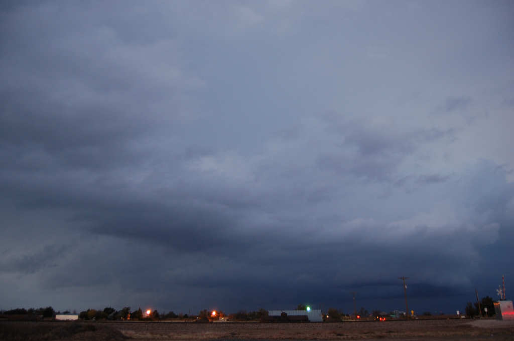
We watched the second storm approach us from the southwest for a good 30 minutes. Even after we left our spot at the Goodnight intersection and went back to I-40, we took our time going back through Groom to double check before heading home. All we could see was a black featureless base. So we started home.
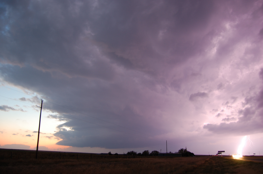

Then we started hearing about the "large and extremely dangerous" tornado reports near Pampa. We were initially skeptical, but seeing pictures begin to show up on social media, we determined the adjectives in the warnings were legitimate. After some deliberating we decided to make another attempt, getting off I-40 at McLean and heading up towards Lefors. As we neared Lefors I swear I saw two power flashes way off in the distance, then we saw what looked to be a dark mass contrasting with background orange light, probably from Pampa. We only saw it for a few seconds. Who knows what it was. There were large tornadoes in the vicinity at the time after all.
We called the chase there. To save a little time, we decided not to go back to I-40 through McLean, but instead to cut through to Wheeler and Elk City. So we kept east on F.M. 2473, a route I had used earlier in the season and thus was familiar with. I neglected to consider how different that route would be at night. It is a narrow two-lane road with no shoulder in a remote area of the county, 15 miles by road to the nearest town of any size, and 20-25 miles from the nearest town that could offer any sort of services. About a mile west of the Kellerville intersection (there's no actual town there, just some abandoned buildings), a fawn or small doe popped out of the tall grass to the right of the road and began running across from right to left. Despite being the same color as the tall dessicated grass flanking the road, I saw it right away and immediately computed that a collision was unavoidable. Going abut at 70-75 mph (the speed limit on that road is 70 mph) I decided not to slam on my brakes in case the ABS didn't hold up, but rather to apply moderate pressure and veer slightly to the left in a vain attempt to avoid a collision. It wasn't enough - we slammed into it around its shoulder-neck-head region on the front right quarter. We never saw the deer after that, so I presume it died. We cleaned up the damage as best we could in the environment. It was around 7:30 PM in mid-November so we were well past last light. There were no lights of any kind around, and low clouds had covered up the moon. There was 25 kt southeasterly sustained winds interacting with power lines nearby, resulting in that all-too-familiar-yet-still-creepy howl. Also there were no other people around as far as we could tell (no other cars on this road until after we got moving again). To say the least, it was eerie in that spot. Frankly I'm impressed I was able to stay focused on the goal just getting out of there.
We limped to Shamrock, but discovered on the way there that the damage had been minor enough to reach highway speeds. In fact, after that, I was able to drive 70+ the rest of the way back to Norman.
Thankfully, the car had comprehensive and collision, so I was only out the $500 deductible. The total damage was around $3,200. As bad as it all was, though, we were pretty lucky. Had the deer been larger or had I been going a different speed, we could've been injured and the car rendered undriveable, at which point we would've been miles from help. This is one reason why I'm not a big fan of chasing after dark.
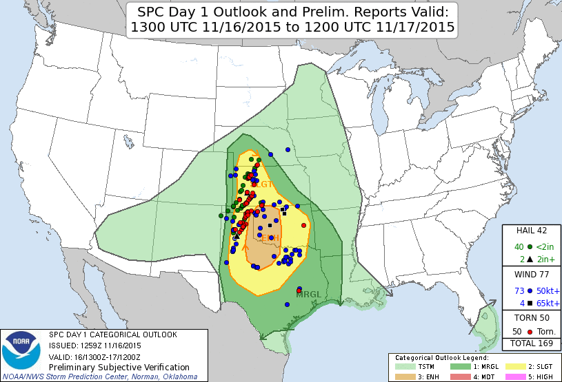
The morning of the event, I noted a difference between the HRRR and 4 km NAM solutions. The 12Z 4 km NAM had depicted the boundary would only just be approaching AMA at 00Z with storms only that far east. I was not excited about the prospect of having to go that far west, especially given how suddenly progs had changed over the past few days. However, my previous post above alluded to the change in forecast. As it turns out, this forecast of lagged ejection of the trough and associated boundaries verified, as evinced by the following mesoanalysis of surface divergence and winds:
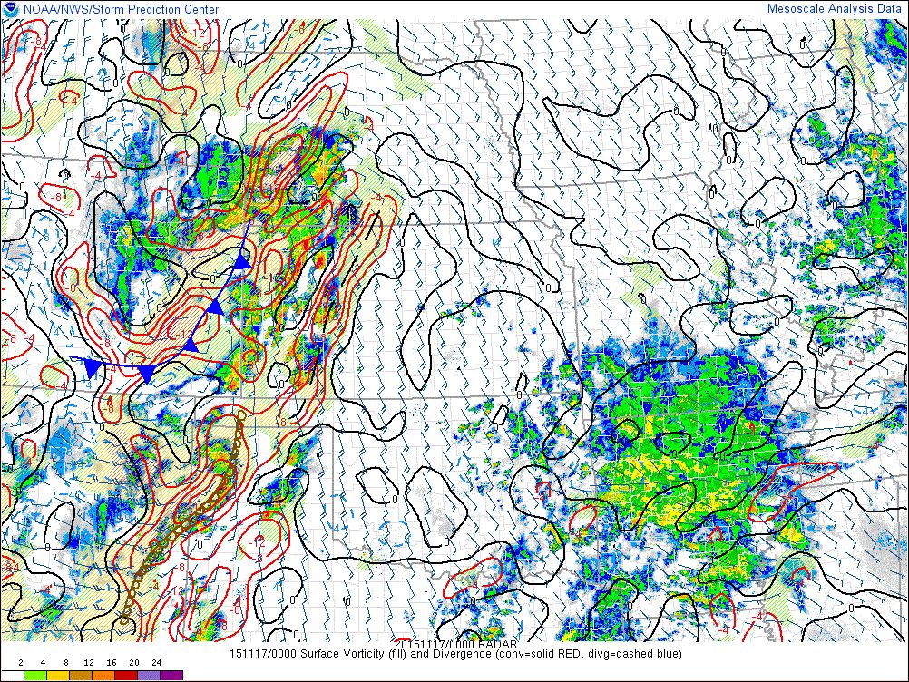
The main boundary was, in fact, west of Amarillo at 00Z. I had been banking on some sort of pre-frontal convergence to fire off storms. This did happen, and we were right on that convergence when it happened (we sat looking at CU towers near Groom at 4 PM).
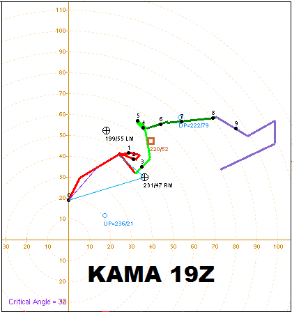
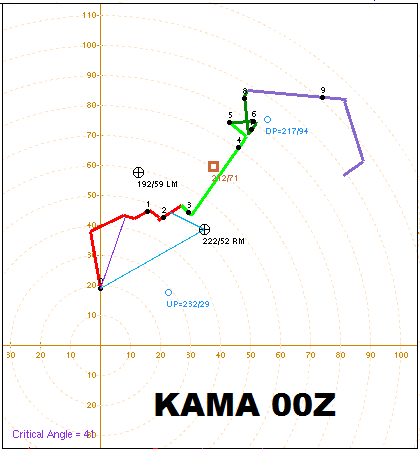
There are many things we should have done differently during the chase. For one, we shouldn't have gone all the way through Palo Duro Canyon to intercept the first storm. I wasn't paying close attention to radar, plus data was intermittent anyway. We had visual of it, but our view of the base was shrouded by the heavy precip. I had assumed the storm would turn to the right eventually, so I was more worried about getting south ahead of the core. As seen by comparing the 19Z and 00Z AMA soundings, the hodograph tilted counterclockwise during the late afternoon, pulling the right-moving storm motion vector to the left. It seemed to me the whole day that storm motions had too little eastward component. I guess the motions do look fairly consistent with the 00Z hodograph.
Second, we just plain shouldn't have given up after last light. After taking a closer look at the images I shot near Goodnight of the first storm passing off to the north, I can pretty clearly discern a horseshoe shaped cloud base. There was even a darker mass embedded within the left edge of it (relative to my view), which would be the correct storm relative location for tornadoes. Even on the second storm, my last few shots showed a clear slot being punched by an RFD. However, the storm had formed several shallow lowerings below the base that all fizzled within minutes.
Third, we should've kept a closer eye on the data. Given the westward location of the storms, I was assuming they were struggling during daylight hours because they didn't have that better moisture that was in place in far W OK. Dewpoints in the eastern TX panhandle at 00Z were barely clipping 60, and closer to where the tornadoes happened, they were only 55-57. I didn't think that was going to be good enough to get the job done, but analyzed MLCAPE got to 1500 and stayed there until after dark.
Also, I haven't chased a lot in the eastern TX panhandle until this year. I'm not at all in love with the road network east of Amarillo. It sucks, actually, especially between TX-207 and U.S. 83 except for a patch between Panhandle, Pampa, Groom, and Conway, and then a strip along U.S. 60 and TX-152 east of Pampa about 10 miles. In future setups in this area, I'm going to seriously consider avoiding this corridor in favor of other areas, especially to the north, in the OK PH/SW KS, or to the south.
Return to 2015 - chasing home page